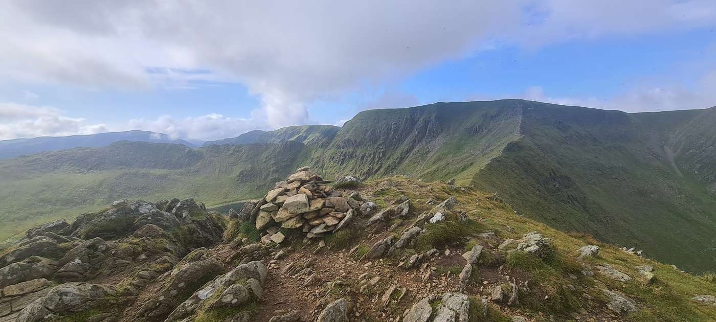
Helvellyn
Helvellyn at 950m (3,117ft) is the most climbed of all the major Lakeland summits, and Wainwright devoted more pages to it than almost any other fell.
Is it worth going? — Today’s conditions & 7-day summit forecast
Modelled guidance for the 950 m summit. Always check the Met Office mountain forecast and MWIS before you set off.
On the summit today (Tue 28 Jul): 13° to 11°C, gusts to 39 mph, 7.0 mm of rain forecast.
Forecast snapshot from 28 Jul 2026, 04:58 UTC — refreshed nightly and updated live in your browser. Temperatures and gusts adjusted to the 950 m summit altitude via Open-Meteo. Summit conditions are always harsher than the valley — check the professional mountain forecasts before you go.
About the walk
Helvellyn
- Height
- 950 m (3,117 ft)
- How long
- ~5–6 h
- How hard
- how hard Helvellyn is depends entirely on the route you pick — and even the walkers’ way is a hard mountain day, not a stroll.
- Weather today
- 🌧️ 13°/11°C, gusts 39 mph
- Is it dangerous?
- Helvellyn deserves respect, but the danger is not where most people think it is.
- Parking
- Steel End, Thirlmere (paid)
Short version: how hard Helvellyn is depends entirely on the route you pick — and even the walkers’ way is a hard mountain day, not a stroll. The two knife-edge ridges and the walking lines are genuinely different propositions, and the gap between them is not subtle.
Striding Edge is the one people mean. Our own assessment rates its exposure Severe — a narrow arête where the drops on both sides are the whole character of the thing, and where a slip in the wrong place is not survivable. It is a Grade 1 scramble: hands out of pockets, and a different mountain again in wind, wet or winter. Swirral Edge, the usual way off, is shorter but is not a consolation prize.
You can avoid both. The walkers’ way up from Swirls reaches the same summit with no arête at all — our exposure grading drops to Moderate. But do not read that as easy: we still rate that route Hard overall, on a Severe sustained pull, and we grade its navigation Hard. That last one is the part that catches people out. The summit plateau is broad and featureless, the ground falls away sharply to the east, and in cloud the honest answer is that you need a map and compass and the ability to use them — the easy way up is not the easy way down.
(These verdicts are editorially assessed from the documented character of the routes; we have not yet walked them ourselves.)
So what is the hardest part? Not one move — that is the honest answer. Striding Edge has no single crux that stops people; its difficulty is sustained, a long stretch of narrow, exposed ground where the demand is unbroken concentration and sure feet rather than one hard step. The place our own hazard data singles out is the one people ask about least: the descent off the summit onto Swirral Edge, where it is easy to start down the wrong line, and where falls toward Red Tarn have been fatal. Most parties are tiring by then and the pull of the obvious-looking ground is strong. If you are going to be careful anywhere, be careful leaving the top. (We haven’t walked this exact line ourselves — the grading is from our route assessment and the hazard record, not a personal ascent.)
Routes up Helvellyn
Hand-mapped, with GPX to download — full maps further down.
Map & nearby Birketts
Skip mapFree mapping: OpenTopoMap / OpenStreetMap (switch layers top-right). Parking positions are approximate.
Nearest parking: Steel End, Thirlmere (paid), about 2.4 km from the summit (straight line). Full parking, toilets and bus details are below.
Birketts near Helvellyn (within 3 km)
These Birkett tops are not Wainwright summits — detour to them on this walk and they are pure profit. Distances are straight-line; allow extra for terrain.
Routes over Helvellyn
A planned line is a suggestion, not a guarantee — conditions change. Navigate independently and carry a map & compass.
✎️ Planned route — drawn but not personally walked or checked yet.
A planned line is a suggestion, not a guarantee — conditions change. Navigate independently and carry a map & compass.
✎️ Helvellyn’s FAQs send nervous walkers here, and rightly. If you want the summit without the exposure of Striding Edge and Swirral Edge, this is the way: a clear path the whole distance, a plateau to walk about on, and the same enormous view east over Red Tarn.
✎️ Planned route — drawn but not personally walked or checked yet.
A planned line is a suggestion, not a guarantee — conditions change. Navigate independently and carry a map & compass.
The View from Helvellyn
A computed 360° skyline — every visible named top labelled by distance and bearing, from the terrain model in perfect clarity, not photographed. Drag to pan; reveal the far four-nations horizon.
What you can see from Helvellyn, by direction
- North: Gategill Fell Top (12 km), Blencathra (13 km), Atkinson Pike (13 km)
- South: The Old Man of Coniston (19 km)
- South-west: Esk Pike (13 km), Bowfell (13 km), Great End (13 km), Shelter Crags (14 km), Pike de Bield (14 km), Crinkle Crags (14 km), Crinkle Crags (14 km), Crinkle Crags (14 km), Crinkle Crags (14 km), Crinkle Crags South Top (14 km), Ill Crag (14 km), Broad Crag (14 km), Scafell Pike (15 km), Lingmell (15 km), Scafell (16 km), Swirl How (16 km), Brim Fell (18 km)
- West: Green Gable (14 km), Great Gable (14 km), Kirk Fell (16 km), Crag Hill (16 km), Eel Crag (16 km), High Stile (17 km), Pillar (17 km), High Stile (18 km), Grasmoor (18 km), Black Crag (18 km), Red Pike (18 km), Scoat Fell (19 km), Haycock (20 km)
- North-west: Skiddaw South Top (16 km), Skiddaw Middle Top (16 km), Skiddaw (16 km), Grisedale Pike (16 km), Skiddaw North Top (16 km), Broad End (17 km)
On the clearest days the far horizon adds: Snowdon (177 km, Wales), Carnedd Llewelyn (164 km, Wales), Merrick (116 km, Scotland), Aran Fawddwy (199 km, Wales), Snaefell (98 km, Isle of Man), Moel Siabod (173 km, Wales), Cairnsmore of Carsphairn (112 km, Scotland), The Cheviot (120 km, England).
Computed from terrain in perfect clarity, not photographed · distances are straight-line.
Computed from Copernicus GLO-30 terrain; distant tops from the Database of British and Irish Hills (opens in new tab) (CC BY 4.0). See how we compute the view · and the summit intervisibility report below.
What you can see from Helvellyn
On a clear day — computed sightlines, curvature- and refraction-corrected.On the clearest days the view reaches across to Wales, Scotland and the Isle of Man.
- Snowdon (Yr Wyddfa) Wales
- Carnedd Llewelyn Wales
- Merrick Scotland
- Snaefell Isle of Man
- Criffel Scotland
- Ingleborough Yorkshire Dales
- Whernside Yorkshire Dales
- Solway Firth bay/estuary
- Great Dun Fell North Pennines
- Morecambe Bay bay/estuary
- Cross Fell North Pennines
All 145 Wainwrights in clear view (nearest first)
Nethermost Pike, Catstye Cam, White Side, Dollywaggon Pike, Raise, Birkhouse Moor, St Sunday Crag, Fairfield, Stybarrow Dodd, Birks, Sheffield Pike, Watson's Dodd, Hart Crag, Steel Fell (Dead Pike - Steel Fell), Armboth Fell (Armboth Fell South Top), Great Rigg, Hart Side, Great Dodd, High Tove, Gibson Knott, Ullscarf, Helm Crag, Calf Crag, Place Fell, Little Hart Crag (Little Hart Crag - West Top), Heron Pike (Rydal), Tarn Crag (Easedale), Angletarn Pikes (Angletarn Pikes North Top), Great Crag (Stonethwaite), Clough Head, Hartsop Dodd, Brock Crags (Wainwright), High Rigg (Naddle Fell), Middle Dodd, Grange Fell (Brund Fell), Red Screes, Blea Rigg, Sergeant Man, Silver How, Rosthwaite Fell - Bessyboot, Stony Cove Pike (Caudale Moor), Rest Dodd, Pavey Ark, Gray Crag, The Nab, Gowbarrow Fell (Wainwright summit), Castle Crag, Thunacar Knott, The Knott (High Street), Harrison Stickle, Thornthwaite Crag, Hallin Fell, Rampsgill Head, High Raise (High Street), Glaramara, High Spy, Cat Bells (Catbells), Maiden Moor, Lingmoor Fell (Brown How), Froswick, Wether Hill, Latrigg, Great Mell Fell, Loadpot Hill, Ill Bell, Dale Head, Rossett Pike, Little Mell Fell, Bonscale Pike, Base Brown, Allen Crags, Blencathra - Hallsfell Top, Yoke, Hindscarth, Esk Pike, Pike of Blisco, Bowfell, Harter Fell (Mardale), Arthur's Pike, Brandreth, Lonscale Fell, Barrow, Great End, Green Gable, Black Fell, Causey Pike, Fleetwith Pike, Crinkle Crags - Long Top (Second Crinkle), Bannerdale Crags, Great Gable, Cold Pike, Souther Fell, Robinson, Kentmere Pike, Ard Crags, Scar Crags, Outerside, Skiddaw Little Man, Holme Fell, Scafell Pike, Lingmell, Wetherlam, Haystacks (Buttermere), Knott Rigg, Sail, Kirk Fell, Bowscale Fell, Carl Side, Dodd (Skiddaw), Crag Hill (Eel Crag), Great Carrs, Scafell, Swirl How, Wandope, Skiddaw, Grisedale Pike, High Crag (Buttermere), Long Side, Whiteless Pike, Ullock Pike, Great Calva, Hopegill Head, Barf, Pillar, Bakestall, Lord's Seat, Brim Fell, Red Pike (Buttermere), Whinlatter (Brown How - Whinlatter), Red Pike (Wasdale), Whiteside (Whiteside West Top), Carrock Fell, Scoat Fell (Little Scoat Fell), The Old Man of Coniston (Coniston Old Man), Broom Fell, Dow Crag, Mellbreak (Mellbreak South Top), High Pike (Caldbeck), Starling Dodd, Haycock, Middle Fell, Sale Fell, Seatallan, Great Borne, Blake Fell
How Helvellyn’s view compares with all 214 — the View Report: every Wainwright ranked by what you can see from the top.
Sightlines from a bare-earth terrain model (forests and buildings not included), corrected for the Earth’s curvature and average atmospheric refraction. “Distant” sightlines and any over 100 km depend on exceptionally clear air. Modelled from Copernicus GLO-30 open elevation data — a guide to the view, not a guarantee of any single one.
Best parking to hike Helvellyn
Where we have the data, each parking spot also shows the nearest public toilets and facilities (cafés, pubs, shops).
Positions are approximate — zoom the map to confirm. Lakeland car parks fill before 9am on fine weekends.
Tip: pan and zoom the interactive map at the top of this page to spot other potential parking near your route.
Water & shelter on the way up
On the Helvellyn & Nethermost Pike via Seat Sandal route:
On the Helvellyn via Striding Edge & Swirral Edge route:
On the Helvellyn from Swirls: the walkers’ way up route:
💧 Treat water from the fell before you drink it. A mapped point is usually a tap or public supply, but never drink untreated from a beck, stream or tarn — even clear-looking hill water can carry giardia or cryptosporidium from livestock or a carcass upstream and leave you seriously ill. Run it through a filter or purifier (a LifeStraw, Sawyer Squeeze or HydraPak) or bring it to a rolling boil first.
On-route facilities © OpenStreetMap contributors, per route — an absent marker doesn’t mean none.
Buses to Helvellyn from Penrith / Ambleside / Windermere
Rural routes change seasonally — confirm on stagecoachbus.com (opens in new tab) or Traveline before relying on a last bus.
My hikes over Helvellyn (Strava)
1 logged hike pass over this summit:
- A few more Wainwrights in the wind and rain (opens in new tab) — 17.6 km · 1347 m ascent · 4h 27m moving · 16 Jul 2023
Interactive route maps and photos load here for visitors with JavaScript. Data from Strava.
Is Helvellyn dangerous?
Helvellyn deserves respect, but the danger is not where most people think it is. The edges — Striding Edge and Swirral Edge — are genuine scrambles with real exposure, and in wind, wet or winter conditions they are serious undertakings. But look at what mountain rescue teams are actually called to, here and across the Lake District: slips, trips and navigation errors, driven by poor decisions far more often than by falls from the edges. Site-wide, slips and trips are 22% of call-outs, and poor decision-making is the most-logged contributory factor — the numbers are in our Mountain Rescue Report.
The summit plateau is the trap. It is broad, featureless and ringed by crags on its eastern side — and in cloud, people walk off it. Getting up Helvellyn is rarely the problem; finding the safe line off it in poor visibility is. If cloud is forecast, that is the hazard to plan for — carry a map and compass and know the bearing off the top before you need it.
You may have arrived here after searching for deaths on Helvellyn. We don’t publish a per-fell death count, because no verified one exists — and a number wouldn’t keep you safe anyway. What will: knowing what actually goes wrong (above), and choosing the right route for the day and for you (below).
Go deeper: the Mountain Rescue Report (what actually goes wrong, in numbers) · Summer on the Fells — the season’s hazards, ranked by evidence.
Hazard & Incident Information for Helvellyn
One of the busiest mountains in England, and correspondingly one of the most rescued. The gravest incidents cluster on the two knife-edge ridges — Striding Edge and Swirral Edge — and on the steep ground falling east to Red Tarn. Winter transforms it: cornice collapses and slips on hard snow account for the most serious accidents and several deaths.
- Striding Edge: An exposed grade 1 scramble. In wind, wet rock, or snow it is genuinely dangerous — turn back if conditions are poor or your party isn't confident.
- Swirral Edge: Steep and exposed, especially the awkward descent onto it from the summit. It is easy to start down the wrong line — falls onto Red Tarn have been fatal.
- Summit plateau and east-facing edge in winter / cloud: Cornices build over the east face; keep well back from the edge and navigate by bearing in poor visibility.
Most common causes: Slips and falls on the edges · Winter falls on hard snow and ice · Navigation errors in cloud · Underestimating the descent
Local Mountain Rescue: Patterdale Mountain Rescue Team (opens in new tab) · Keswick Mountain Rescue Team (opens in new tab) · Reviewed 17 Jul 2026
Safety: Hazard guidance compiled from published Mountain Rescue reports and well-documented accident history - editorial background, not a live feed of callouts. Always check current conditions, carry proper navigation equipment, and seek qualified instruction before heading onto the fells. In an emergency, call 999, ask for Police, then Mountain Rescue.
Don’t drink from Glenridding Beck
On the way up you cross Glenridding Beck, which runs below the old Greenside lead mine. The Environment Agency records it carrying dissolved lead above the level that is safe to drink. This is not the usual hill-water risk: a squeeze or hollow-fibre filter (LifeStraw, Sawyer and the like) removes none of these dissolved metals, and boiling only concentrates them. Carry your own water for this walk and don’t refill from the beck.
What’s actually in this beck — we mapped every mine-fed one →
Metal-mine water data © Environment Agency (Open Government Licence v3.0).
Navigating Helvellyn in cloud
SevereWalkable ground sits close to a lethal drop — in cloud it’s easy to walk straight onto steep ground. A serious place to be caught in cloud: carry map and compass (or GPS) and know how to use them, or save it for a clear day.
In winter — snow, whiteout, cornices, buried features — every top demands full winter navigation skills whatever its band, and a broad, gentle summit can be the worst place of all. See walking in bad weather and the navigation guide.
How Helvellyn compares with all 214 — the Clag Index: navigating in cloud. A relative, deliberately cautious guide; the site can’t navigate for you.
Frequently asked questions about Helvellyn
How high is Helvellyn?
Helvellyn is 950 m (3,117 ft) — the third-highest mountain in England, after Scafell Pike (978 m) and Scafell (964 m). It is the highest point of the Eastern Fells and one of only four English peaks over 3,000 feet.
Where is Helvellyn?
Helvellyn stands in the Eastern Fells of the Lake District, on the ridge between Thirlmere (west) and Ullswater (east). The usual bases are Glenridding or Patterdale on the Ullswater side — for Striding Edge — and the Swirls car park at Thirlmere for the walkers’ route; Keswick and Grasmere are both within about 20 minutes’ drive.
Is Helvellyn suitable for beginners and children?
It depends entirely on the route. Helvellyn is England's third-highest mountain at 950 m (3,117 ft), and its famous Striding Edge approach is a serious, exposed scramble that is not suitable for beginners or young children. However, the walkers' paths from the west (Thirlmere) make a far gentler ascent that confident first-timers and older children can manage in good weather.
- Beginners / families: use the Thirlmere paths (Wythburn or Helvellyn Gill), which avoid all the scrambling.
- Striding / Swirral Edge: only for those comfortable with steep drops and hands-on scrambling, and best avoided in wind, ice or with nervous children.
Whichever route, treat it as a full mountain day: proper kit, an early start and a willingness to turn back.
Sources: Keswick.org — Helvellyn from Thirlmere (opens in new tab) · Ramblers — guide to Helvellyn (opens in new tab)
What is the easiest and shortest way up Helvellyn?
The easiest and shortest ascent is from Thirlmere on the western side. The route from Wythburn, or up the Helvellyn Gill path from the Swirls car park, is roughly 4–5 miles (around 6–8 km) round trip with about 700–720 m of ascent — and crucially it avoids Striding Edge and Swirral Edge entirely.
It is still a steep, sustained climb on a clear path, but there is no scrambling and no knife-edge exposure. This is the route to choose if you want the summit without the drama, or to escape the ridges if the weather turns.
Sources: Keswick.org — Helvellyn from Thirlmere (opens in new tab)
How dangerous is Striding Edge, and how hard is the scramble?
Striding Edge is a Grade 1 scramble along a narrow, exposed rock arête with steep drops on both sides, finishing with an awkward little down-climb known as the "bad step" before the final pull to the summit. In dry, calm conditions a confident, sure-footed walker can cross it without using ropes, but it demands a head for heights.
It is also the most accident-prone ridge in the Lake District and has claimed lives over the years, particularly in winter when snow and ice turn it into serious mountaineering terrain needing an ice axe, crampons and experience.
- Avoiding it: take the Thirlmere paths from the west instead — they reach the same summit with no scrambling.
- Crossing it: go in good weather, keep just below the crest on the path in strong wind, and never attempt it in winter without the right kit and skills.
This is editorial safety background, not a live conditions report — always check the mountain forecast and your own ability before committing.
Sources: Ramblers — guide to Helvellyn via Striding Edge (opens in new tab) · Patterdale Mountain Rescue Team (opens in new tab)
Do you need walking boots, or can you climb Helvellyn in trainers?
Walking boots are strongly recommended, and on Striding Edge they are essential. The ground is rocky and often wet, and on the ridges you want stiff soles and ankle support for grip and security on uneven rock. Trainers offer little protection and make slips far more likely.
Pack for a mountain whatever the valley weather: boots, waterproofs, a warm layer, food and water, a head torch, a charged phone, and a map and compass you can actually use. The summit plateau is exposed and can be cold and clagged-in even on a fine day below.
How long does it take to walk up Helvellyn?
Plan on 4 to 6 hours for the round trip. The shortest Thirlmere routes can be done in around 3 to 4 hours by a fit walker; the classic horseshoe from Glenridding over Striding Edge and back down Swirral Edge is longer and slower — typically 5 to 7 hours — because the scrambling and the crowds slow you down.
Your time depends on the route, your fitness, group size and the weather. Always aim to be off the ridges and heading down with daylight to spare.
Sources: Keswick.org — Helvellyn from Thirlmere (opens in new tab)
Is Helvellyn harder than Snowdon, Scafell Pike or Ben Nevis?
By height, Helvellyn (950 m) is the lowest of the four — below Scafell Pike (978 m), Snowdon / Yr Wyddfa (1,085 m) and Ben Nevis (1,345 m). But difficulty is about the route, not just the height.
- Via the Thirlmere walkers' paths, Helvellyn is comparable to, or easier than, the standard routes on the others — a steep walk with no scrambling.
- Via Striding Edge, it is arguably the most exposed of the four, with scrambling that none of the normal tourist routes up Snowdon, Scafell Pike or Ben Nevis demand.
So Helvellyn can be the gentlest or the most thrilling of the group depending purely on which way you go up.
Is there phone signal on Helvellyn, and how do I check it is safe today?
Mobile coverage is patchy and cannot be relied on — you may get a signal on the summit or ridges with some networks, but there are many dead spots on the approaches and in the valleys. Never depend on your phone for navigation or rescue; carry a map and compass, and tell someone your route and expected return time.
Before you go, check a mountain forecast rather than the town forecast, as conditions on top are often dramatically worse:
- Met Office Lake District mountain forecast.
- Mountain Weather Information Service (MWIS).
In an emergency, call 999, ask for Police, then Mountain Rescue; if you have no signal, the 999-by-SMS service can sometimes get a message out where a call fails (register beforehand).
Sources: Met Office — Lake District mountain forecast (opens in new tab) · Mountain Weather Information Service (MWIS) (opens in new tab)
Questions drawn from real Google “People also ask” searches; answers written and fact-checked by us. · Reviewed 2026-06-14 · Suggest a question or correction (opens in new tab)
Other fells near Helvellyn
- Arnison Crag
- Birkhouse Moor
- Birks
- Catstye Cam
- Clough Head
- Dollywaggon Pike
- Dove Crag
- Fairfield
- Glenridding Dodd
- Gowbarrow Fell (Wainwright summit)
- Great Dodd
- Great Mell Fell
- Great Rigg
- Hart Crag
- Hart Side
- Hartsop Above How (Gill Crag - Hartsop Above How)
- Heron Pike (Rydal)
- High Hartsop Dodd
- High Pike (Scandale)
- Little Hart Crag (Little Hart Crag - West Top)
- Little Mell Fell
- Low Pike
- Middle Dodd
- Nab Scar
- Nethermost Pike
- Raise
- Red Screes
- Seat Sandal
- Sheffield Pike
- St Sunday Crag
- Stone Arthur
- Stybarrow Dodd
- Watson's Dodd
- White Side
Maps & guidebooks for Helvellyn
- Buy on Amazon (opens in new tab)
- Buy on Amazon (opens in new tab)
- Buy on Amazon (opens in new tab)
- Buy on Amazon (opens in new tab)
- Buy on Amazon (opens in new tab)
As an Amazon Associate we earn from qualifying purchases — at no extra cost to you. How affiliate links work →