Latrigg
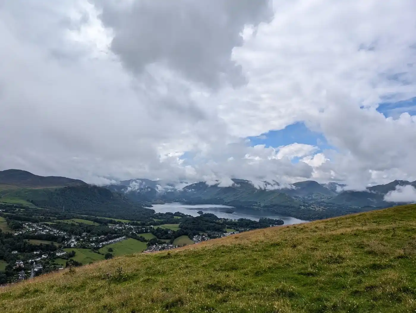
Latrigg at 368m (1,207ft) is the little fell above Keswick, its summit giving one of the finest and most accessible viewpoints of Derwent Water and the surrounding fells in the whole Lake District.
Is it worth going? — Today’s conditions & 7-day summit forecast
Modelled guidance for the 369 m summit. Always check the Met Office mountain forecast and MWIS before you set off.
On the summit today (Tue 28 Jul): 17° to 15°C, gusts to 28 mph, 2.9 mm of rain forecast.
Forecast snapshot from 28 Jul 2026, 04:58 UTC — refreshed nightly and updated live in your browser. Temperatures and gusts adjusted to the 369 m summit altitude via Open-Meteo. Summit conditions are always harsher than the valley — check the professional mountain forecasts before you go.
About the walk
Latrigg
- How long
- ~1.5–2 h
- Height
- 369 m (1,211 ft)
Routes up Latrigg
Hand-mapped, with GPX to download — full maps further down.
Map & nearby Birketts
Skip mapFree mapping: OpenTopoMap / OpenStreetMap (switch layers top-right). Parking positions are approximate.
Nearest parking: Gale Road / Latrigg top (free), about 0.5 km from the summit (straight line). Full parking, toilets and bus details are below.
Birketts near Latrigg (within 3 km)
These Birkett tops are not Wainwright summits — detour to them on this walk and they are pure profit. Distances are straight-line; allow extra for terrain.
Routes over Latrigg
A planned line is a suggestion, not a guarantee — conditions change. Navigate independently and carry a map & compass.
The View from Latrigg
A computed 360° skyline — every visible named top labelled by distance and bearing, from the terrain model in perfect clarity, not photographed. Drag to pan; reveal the far four-nations horizon.
What you can see from Latrigg, by direction
- North-east: Knowe Crags (4 km)
- South-east: Little Dodd (7 km), Great Dodd (8 km), Watson's Dodd (8 km), Stybarrow Dodd (9 km), Raise (10 km), White Side (10 km), Helvellyn Lower Man (11 km), Catstye Cam (11 km), Helvellyn (12 km)
- South: Glaramara (15 km), Allen Crags (17 km), Great End (17 km), Esk Pike (18 km), Broad Crag (18 km), Scafell Pike (19 km), Bowfell (19 km), Scafell (20 km), Shelter Crags (20 km), Crinkle Crags (20 km), Crinkle Crags (20 km), Crinkle Crags (20 km), Crinkle Crags (20 km), Crinkle Crags South Top (20 km), Grey Friar (24 km), Dow Crag (27 km)
- South-west: Sail (9 km), Crag Hill (10 km), Eel Crag (10 km), High Stile (15 km), High Stile (15 km), Red Pike (15 km), Green Gable (15 km), Great Gable (16 km), Pillar (17 km), Scoat Fell (18 km), Lingmell (18 km)
- West: Grisedale Pike (8 km), Sand Hill (10 km)
- North-west: Skiddaw South Top (4 km)
On the clearest days the far horizon adds: Cairnsmore of Fleet (89 km, Scotland), Lamachan Hill (99 km, Scotland), Millfore (95 km, Scotland), Fell of Fleet (85 km, Scotland), Pibble Hill (83 km, Scotland), Bengray (74 km, Scotland).
Computed from terrain in perfect clarity, not photographed · distances are straight-line.
Computed from Copernicus GLO-30 terrain; distant tops from the Database of British and Irish Hills (opens in new tab) (CC BY 4.0). See how we compute the view · and the summit intervisibility report below.
Latrigg is one of our picked Lake District viewpoints — what you can see from it, when the light is best, and where to park.
What you can see from Latrigg
On a clear day — computed sightlines, curvature- and refraction-corrected.- Great Dun Fell North Pennines
- Cross Fell North Pennines
All 63 Wainwrights in clear view (nearest first)
Lonscale Fell, Skiddaw Little Man, Walla Crag, High Rigg (Naddle Fell), Carl Side, Dodd (Skiddaw), Bleaberry Fell, Clough Head, Barrow, Cat Bells (Catbells), Raven Crag, Barf, Causey Pike, Outerside, Great Dodd, Watson's Dodd, Lord's Seat, Maiden Moor, Scar Crags, Grisedale Pike, Stybarrow Dodd, Grange Fell (Brund Fell), Ard Crags, Broom Fell, Whinlatter (Brown How - Whinlatter), Sail, Castle Crag, High Spy, Raise, Crag Hill (Eel Crag), Sale Fell, White Side, Knott Rigg, Great Crag (Stonethwaite), Hindscarth, Dale Head, Robinson, Catstye Cam, Helvellyn, Great Mell Fell, Rosthwaite Fell - Bessyboot, Base Brown, Little Mell Fell, Glaramara, Seat Sandal, High Stile, Red Pike (Buttermere), Green Gable, Seathwaite Fell (Wainwright summit), Great Gable, Pillar, Allen Crags, Great End, Esk Pike, Scoat Fell (Little Scoat Fell), Lingmell, Scafell Pike, Bowfell, Scafell, Crinkle Crags - Long Top (Second Crinkle), Cold Pike, Grey Friar, Dow Crag
How Latrigg’s view compares with all 214 — the View Report: every Wainwright ranked by what you can see from the top.
Sightlines from a bare-earth terrain model (forests and buildings not included), corrected for the Earth’s curvature and average atmospheric refraction. “Distant” sightlines and any over 100 km depend on exceptionally clear air. Modelled from Copernicus GLO-30 open elevation data — a guide to the view, not a guarantee of any single one.
Best parking to hike Latrigg
Where we have the data, each parking spot also shows the nearest public toilets and facilities (cafés, pubs, shops).
Positions are approximate — zoom the map to confirm. Lakeland car parks fill before 9am on fine weekends.
Tip: pan and zoom the interactive map at the top of this page to spot other potential parking near your route.
Buses to Latrigg from Penrith / Ambleside / Windermere
Rural routes change seasonally — confirm on stagecoachbus.com (opens in new tab) or Traveline before relying on a last bus.
My hikes over Latrigg (Strava)
1 logged hike pass over this summit:
- Lattrig - most cheatingest fell there is. You basically drive to the summit. (opens in new tab) — 2.2 km · 88 m ascent · 30 min moving · 27 Jul 2024
Interactive route maps and photos load here for visitors with JavaScript. Data from Strava.
Hazard & Incident Information for Latrigg
A short, well-pathed fell on the edge of Keswick with no significant hazards — a popular first hill and an easy evening stroll. The only real risks are the ones common to any fell: deteriorating weather, and underestimating a hill simply because it is small.
Local Mountain Rescue: Keswick Mountain Rescue Team (opens in new tab) · Reviewed 13 Jun 2026
Safety: Hazard guidance compiled from published Mountain Rescue reports and well-documented accident history - editorial background, not a live feed of callouts. Always check current conditions, carry proper navigation equipment, and seek qualified instruction before heading onto the fells. In an emergency, call 999, ask for Police, then Mountain Rescue.
Navigating Latrigg in cloud
StraightforwardA broad, gently-sloping top with little to steer by — easy to lose your bearings and hard to relocate in mist. Navigation here is relatively straightforward even in cloud — but carry map and compass and know how to use them; a low score never means “safe”.
In winter — snow, whiteout, cornices, buried features — every top demands full winter navigation skills whatever its band, and a broad, gentle summit can be the worst place of all. See walking in bad weather and the navigation guide.
How Latrigg compares with all 214 — the Clag Index: navigating in cloud. A relative, deliberately cautious guide; the site can’t navigate for you.
Frequently asked questions about Latrigg
Is Latrigg easy to climb?
Yes — Latrigg (368 m / 1,207 ft) is one of the easiest fells in the Lakes, and the gentlest summit near Keswick. There's no scrambling, no sheer edges and only a gradual incline on clear, well-made paths, so anyone of moderate fitness can manage it.
Wainwright famously wrote that anybody who couldn't manage Latrigg should give up the idea of becoming a fellwalker — it's a perfect first fell.
Is Latrigg easier than Catbells?
Marginally, yes. Both are short beginner fells with big views, but Catbells has two short polished rock steps where most people use their hands, while Latrigg has none — it's grass and clear track the whole way, with a much gentler start from Gale Road.
A fair rule: Latrigg is the gentler first hill and the one that suits pushchairs and wheels; Catbells feels slightly more like mountaineering and rewards you with the closer lake views. Ideal first and second fells, in that order.
Is there a wheelchair-accessible path up Latrigg?
Yes — Latrigg is Miles Without Stiles route 38: a well-maintained path from the Gale Road car park (grid NY 281253), about 1 km each way, designed with wheelchair and pram users in mind. The national park rates it "accessible for some": parts are steep and uneven, mobility scooters should be class 2 or 3, and you return the same way.
There are no toilets on the route — the nearest are in Keswick. Check the national park's Miles Without Stiles page for current conditions.
Sources: Lake District National Park — Miles Without Stiles 38: Latrigg (opens in new tab)
What is the easiest route up Latrigg, and how long is it?
The shortest way is from the free Gale Road car park (behind the fell), which starts high — only about 80 m of ascent and roughly a mile each way on a clear path to the summit, taking well under an hour.
A lovely longer circular from Keswick itself, using the old railway line, is about 9.5 km (6 miles) and takes 2.5–3 hours on easy ground.
Is Latrigg good for families and children?
It's one of the best family fells in the Lakes — short, gentle and safe, with huge rewards for little effort. From Gale Road even young children can reach the summit, and the lower circular along the old Keswick railway line is largely pushchair- and wheelchair-friendly to a point.
There are no sheer drops on the usual route, but it's still open fellside, so keep little ones close and dress for the breeze on top.
Can you take a dog up Latrigg?
Yes — it's a popular, dog-friendly walk on good paths, ideal for a quick outing from Keswick. Just keep dogs on a lead around the grazing sheep on the open fell, and under control near the road at the Gale Road car park.
What are the views like from Latrigg?
Out of all proportion to the effort. The summit gives a superb panorama over Keswick and Derwentwater, along Bassenthwaite Lake, and across to the Newlands and North Western Fells, with mighty Skiddaw rising behind. On a clear day you can pick out Scafell Pike and Great Gable far to the south.
It's one of the finest viewpoints in the Lakes for so little climbing — which is why it's so popular at sunset.
Sources: Keswick.org — Latrigg walking route (opens in new tab)
Do you need walking boots for Latrigg?
In dry summer conditions sturdy trainers are fine on the good paths, but walking boots or shoes with decent grip are better, as the grass and tracks get muddy and slippery after rain. It's still a fell, so take a waterproof and a warm layer — the breezy summit can be much cooler than Keswick.
Carry water and check the forecast; in winter the paths can be icy.
Questions drawn from real Google “People also ask” searches; answers written and fact-checked by us. · Reviewed 2026-07-20 · Suggest a question or correction (opens in new tab)
Other fells near Latrigg
Maps & guidebooks for Latrigg
- Buy on Amazon (opens in new tab)
- Buy on Amazon (opens in new tab)
- Buy on Amazon (opens in new tab)
- Buy on Amazon (opens in new tab)
- Buy on Amazon (opens in new tab)
As an Amazon Associate we earn from qualifying purchases — at no extra cost to you. How affiliate links work →