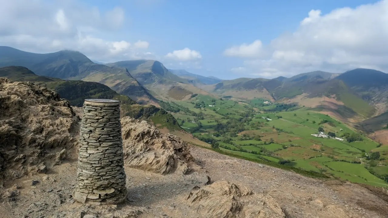
Cat Bells (Catbells)
Catbells is one of Alfred Wainwright's great favourites, and his fondness for it shines through in The North-Western Fells — he saw it as a 'family fell,' approachable enough for grandparents and young children to climb together, yet rewarding with shapely, sun-warmed slopes and a genuinely striking position above Derwent Water.
Is it worth going? — Today’s conditions & 7-day summit forecast
Modelled guidance for the 451 m summit. Always check the Met Office mountain forecast and MWIS before you set off.
On the summit today (Tue 28 Jul): 16° to 14°C, gusts to 37 mph, 4.3 mm of rain forecast.
Forecast snapshot from 28 Jul 2026, 04:58 UTC — refreshed nightly and updated live in your browser. Temperatures and gusts adjusted to the 451 m summit altitude via Open-Meteo. Summit conditions are always harsher than the valley — check the professional mountain forecasts before you go.
About the walk
Cat Bells (Catbells)
- Getting there
- Keswick Launch to Hawse End
- How hard
- Catbells is a small fell, but not an easy one
- How long
- ~2.5–3 h
- Height
- 451 m (1,480 ft)
Short version: Catbells is a small fell, but not an easy one — a friendly big view with two short rocky steps where you will want your hands. For a confident walker or child on a fine day it is about the best first proper fell in the Lakes; it is not a stroll, and most of the trouble here is slips on the way down.
Is it OK for beginners? Yes — on a clear day it is roughly as good as a first fell gets: a short climb, a single obvious ridge you cannot really get lost on, and a reward out of all proportion to the effort. The honest catch is underfoot — two brief rock steps, worn slippery by sheer numbers, and a steep, eroded descent. Wear grippy boots or shoes, use your hands on the steps, and come down the gentler terrace path above the lake rather than straight down the ridge, which is where people slip.
Is Latrigg easier than Catbells?
By our five-axis reading of the two walks, yes — underfoot. Latrigg is the gentler hill: a graded path the whole way with no hands-on rock, where we grade Catbells’ terrain harder for its two rocky steps and its climb Severe for steepness against Latrigg’s moderate pull. The one thing Latrigg asks that Catbells does not is navigation — its broad, featureless top is genuinely awkward in cloud (we grade it Hard), where Catbells is a single ridge you follow by eye. So for a clear-day family walk, Latrigg is the easier of the two, and both are short; in mist, Catbells is the one you are less likely to lose.
Is Catbells a Grade 1 scramble? No — it is not a graded scramble. But the honest answer is better than yes or no, so here is exactly what you will meet, in our own words from the route: “Good path, but two short rocky steps where you will want your hands, on rock worn slippery.” Two brief moves, hands out of pockets, no rope and no real exposure — well short of a scramble, but enough to catch out anyone treating it as a walk in trainers.
Can you take a dog up Catbells? Yes. Our Stile & Gate Census found gates and kissing gates only on the ridge route — no stiles to lift a dog over — so a dog can do the whole walk. Keep it on a short lead across the lower fields, where there is livestock.
What did Wainwright make of it? He was fond of Catbells and cast it as a fell for the whole family — while noting, drily, that its little rock steps have tripped up a good many grown-ups too. We would put it the same way: welcoming, and not to be taken for granted.
How we know: these are our own difficulty gradings from the route we have mapped over Catbells — length and steepness from the terrain model, and terrain, navigation and exposure assessed editorially. We flag on the route itself that it is drawn but not yet personally walked; the reading is honest about that, which is exactly why you can trust it.
Routes up Cat Bells (Catbells)
Hand-mapped, with GPX to download — full maps further down.
Map & nearby Birketts
Skip mapFree mapping: OpenTopoMap / OpenStreetMap (switch layers top-right). Parking positions are approximate.
Nearest parking: Little Town, Newlands (paid, small), about 1.2 km from the summit (straight line). Full parking, toilets and bus details are below.
Birketts near Cat Bells (Catbells) (within 3 km)
These Birkett tops are not Wainwright summits — detour to them on this walk and they are pure profit. Distances are straight-line; allow extra for terrain.
Routes over Cat Bells (Catbells)
A planned line is a suggestion, not a guarantee — conditions change. Navigate independently and carry a map & compass.
✎️ Catbells is the fell that makes people fall in love with the Lakes, and its access is the best story on this site: the Keswick launch to Hawse End, or the bus, and you are at the foot of it without a car. Wainwright called it a family fell — but he also noted, drily, that its rocky steps have caught out plenty of grown-ups.
✎️ Planned route — drawn but not personally walked or checked yet.
A planned line is a suggestion, not a guarantee — conditions change. Navigate independently and carry a map & compass.
The View from Cat Bells (Catbells)
A computed 360° skyline — every visible named top labelled by distance and bearing, from the terrain model in perfect clarity, not photographed. Drag to pan; reveal the far four-nations horizon.
What you can see from Cat Bells (Catbells), by direction
- North: Skiddaw Lesser Man (8 km), Skiddaw Little Man (8 km), Jenkin Hill (8 km), Carl Side (8 km), Skiddaw South Top (9 km)
- North-east: Knowe Crags (10 km), Gategill Fell Top (10 km), Blencathra (11 km), Doddick Fell (12 km)
- East: Watson's Dodd (9 km), Great Dodd (10 km), White Side (10 km), Stybarrow Dodd (10 km), Raise (10 km), Catstye Cam (11 km)
- South-east: Helvellyn Lower Man (10 km), Helvellyn (11 km), Nethermost Pike (11 km), High Crag (12 km), Dollywaggon Pike (12 km), Seat Sandal (13 km), Fairfield (14 km), Great Rigg (15 km)
- South: Combe Head (9 km), Glaramara (9 km), High Raise (11 km), Great End (12 km), Esk Pike (12 km), Harrison Stickle (13 km), Bowfell (13 km), Black Sails (20 km)
- South-west: High Crag (9 km), Red Pike (9 km), Steeple (12 km)
- West: Crag Hill (5 km), Eel Crag (5 km), Wandope (6 km), Sand Hill (6 km)
- North-west: Grisedale Pike (5 km), Hobcarton Crag (6 km)
On the clearest days the far horizon adds: Green Lowther (98 km, Scotland), White Coomb (96 km, Scotland), Queensberry (84 km, Scotland), Culter Fell (111 km, Scotland), Gathersnow Hill (107 km, Scotland), Ballencleuch Law (90 km, Scotland), Hart Fell (95 km, Scotland), Croft Head (86 km, Scotland).
Computed from terrain in perfect clarity, not photographed · distances are straight-line.
Computed from Copernicus GLO-30 terrain; distant tops from the Database of British and Irish Hills (opens in new tab) (CC BY 4.0). See how we compute the view · and the summit intervisibility report below.
Cat Bells (Catbells) is one of our picked Lake District viewpoints — what you can see from it, when the light is best, and where to park.
What you can see from Cat Bells (Catbells)
On a clear day — computed sightlines, curvature- and refraction-corrected.All 63 Wainwrights in clear view (nearest first)
Maiden Moor, Barrow, Causey Pike, Scar Crags, Walla Crag, Ard Crags, Outerside, Castle Crag, Grange Fell (Brund Fell), Bleaberry Fell, Hindscarth, Sail, High Seat, Knott Rigg, Crag Hill (Eel Crag), Grisedale Pike, Wandope, High Tove, Latrigg, Whiteless Pike, High Rigg (Naddle Fell), Rosthwaite Fell - Bessyboot, Dodd (Skiddaw), Barf, Lord's Seat, Skiddaw Little Man, Carl Side, Lonscale Fell, Eagle Crag, Long Side, High Crag (Buttermere), Ullock Pike, Ullscarf, Sergeant's Crag, Watson's Dodd, Skiddaw, Glaramara, Red Pike (Buttermere), Clough Head, Great Dodd, White Side, Stybarrow Dodd, Raise, Helvellyn, High Raise (High White Stones), Starling Dodd, Catstye Cam, Blencathra - Hallsfell Top, Nethermost Pike, Allen Crags, Mungrisdale Common, Steeple, Dollywaggon Pike, Esk Pike, Thunacar Knott, Pike of Stickle, Seat Sandal, Harrison Stickle, Loft Crag, Bowfell, Fairfield, Great Rigg, Binsey
How Cat Bells (Catbells)’s view compares with all 214 — the View Report: every Wainwright ranked by what you can see from the top.
Sightlines from a bare-earth terrain model (forests and buildings not included), corrected for the Earth’s curvature and average atmospheric refraction. “Distant” sightlines and any over 100 km depend on exceptionally clear air. Modelled from Copernicus GLO-30 open elevation data — a guide to the view, not a guarantee of any single one.
Getting to Cat Bells (Catbells)
Parking is the single most-searched thing about Catbells — and the honest truth is that the little parking at the foot of the fell fills fast on any decent day. The good news: this is one fell you really do not need a car for. Three honest ways to the foot of it:
Walk from Keswick
1 h 15 min · 4.18 km · essentially flat
The flat, pretty way in — out of Keswick through Portinscale and along the western shore of Derwentwater to Hawse End, at the foot of the north ridge. No parking to fret over, and the walk is part of the day.
The Chalet Tearooms & Restaurant (Portinscale) is on the walking line — a genuine reason to walk rather than drive. We don’t publish its opening hours; check them before you count on it.
Lee has walked it: “not difficult and actually quite enjoyable.”
Keswick Launch to Hawse End
The best arrival in the Lakes. The Keswick Launch crosses Derwentwater and stops at Hawse End, a few minutes’ walk from the foot of the ridge — no car, no parking, and the lake as your approach. Check the current timetable and the last boat back before you set off.
Driving is a gamble
The roadside parking at Hawse End / Gutherscale is tiny and the verges fill early — on a fine day it is a gamble. If you must drive, come very early or very late, or park at Little Town in Newlands and climb from the quieter side. Better still, take the 77 bus from Keswick, or the launch.
We keep this current because the mapping apps do not: some still list a handful of spaces at the car park that have not reflected reality for years.
Best parking to hike Cat Bells (Catbells)
Where we have the data, each parking spot also shows the nearest public toilets and facilities (cafés, pubs, shops).
Positions are approximate — zoom the map to confirm. Lakeland car parks fill before 9am on fine weekends.
Tip: pan and zoom the interactive map at the top of this page to spot other potential parking near your route.
Water & shelter on the way up
On the Catbells, Maiden Moor & High Spy route:
On the Catbells: the short way up route:
On-route facilities © OpenStreetMap contributors, per route — an absent marker doesn’t mean none.
Buses to Cat Bells (Catbells) from Penrith / Ambleside / Windermere
Rural routes change seasonally — confirm on stagecoachbus.com (opens in new tab) or Traveline before relying on a last bus.
My hikes over Cat Bells (Catbells) (Strava)
1 logged hike pass over this summit:
- Was supposed to be grim so did a tourist route. It wasn't. (opens in new tab) — 21.4 km · 866 m ascent · 4h 53m moving · 9 May 2026
Interactive route maps and photos load here for visitors with JavaScript. Data from Strava.
Hazard & Incident Information for Cat Bells (Catbells)
A short, hugely popular fell that lulls walkers into a false sense of ease. The recurring incidents are slips and trips on the polished rock steps near the summit and on the steep, eroded descent — often involving people in unsuitable footwear, families, or those caught out by how rocky this 'easy' little hill actually is.
- Summit rock steps: Smooth, polished rock that is slippery when wet, with short scrambly moves where a slip can mean a real fall. Use your hands and take care.
- Steep descent toward Hause Gate: Loose and eroded — a common spot for slips. Proper footwear strongly advised.
Most common causes: Slips on wet polished rock · Trips on the eroded descent · Unsuitable footwear
Local Mountain Rescue: Keswick Mountain Rescue Team (opens in new tab) · Reviewed 13 Jun 2026
Safety: Hazard guidance compiled from published Mountain Rescue reports and well-documented accident history - editorial background, not a live feed of callouts. Always check current conditions, carry proper navigation equipment, and seek qualified instruction before heading onto the fells. In an emergency, call 999, ask for Police, then Mountain Rescue.
Navigating Cat Bells (Catbells) in cloud
StraightforwardA broad, gently-sloping top with little to steer by — easy to lose your bearings and hard to relocate in mist. Navigation here is relatively straightforward even in cloud — but carry map and compass and know how to use them; a low score never means “safe”.
In winter — snow, whiteout, cornices, buried features — every top demands full winter navigation skills whatever its band, and a broad, gentle summit can be the worst place of all. See walking in bad weather and the navigation guide.
How Cat Bells (Catbells) compares with all 214 — the Clag Index: navigating in cloud. A relative, deliberately cautious guide; the site can’t navigate for you.
Frequently asked questions about Cat Bells (Catbells)
Is Cat Bells a difficult walk?
No — Cat Bells is one of the Lake District's easiest and most popular fells, often called the "family fell." At just 451 m (1,481 ft) above Derwentwater near Keswick, it is a short, rewarding climb with huge views for relatively little effort.
That said, it is still a proper little mountain: the path is steep in places, there is a short rocky step or two near the top, and the ridge has steep drops on either side. Take it at a steady pace and it is well within the reach of most reasonably mobile walkers.
Sources: Keswick.org — Catbells walking route (opens in new tab) · Countryfile — guide to Cat Bells (opens in new tab)
Is Cat Bells suitable for children and beginners?
Yes — it is a favourite first fell for families and new hill walkers, which is exactly why it is nicknamed the family fell. Children who are steady on their feet usually love it, and it is a great confidence-builder before tackling bigger hills.
If you want something gentler still, Latrigg is the easier of the two — grass and clear track the whole way, with no rock steps.
A few sensible precautions:
- Keep younger children close on the short rocky steps and along the ridge, where there are steep drops.
- Pick a clear, calm day — wind and wet rock make the scrambly bits trickier.
- Wear proper footwear and bring layers, snacks and water.
Sources: Countryfile — guide to Cat Bells (opens in new tab)
Does Cat Bells involve scrambling?
Only a little. There are one or two short, easy scrambly steps where you will use your hands on the rock — most notably a rocky section partway up and just below the summit — but nothing technical or exposed enough to count as a graded scramble. Most walkers, including children, manage them without trouble.
The rock is polished and slippery when wet from generations of boots, so take care in the rain and give yourself a moment on the steps rather than rushing.
Sources: Live for the Outdoors — Cat Bells route (opens in new tab)
How long is the Cat Bells walk, and is it a circular route?
The classic out-and-back over the summit from Hawes End is about 3.5 miles (6 km) and takes most people 2 to 3 hours. It can easily be made into a circular walk — a popular loop returns along the shore of Derwentwater, and longer circuits via Manesty and the lakeside take 3 to 4 hours.
- Quick there-and-back: Hawes End up and down — around 2 hours.
- Scenic circular: over Cat Bells and back by the lake — 3 to 4 hours.
Sources: Keswick.org — Catbells walking route (opens in new tab)
Do you need walking boots, or can you do Cat Bells in trainers?
Walking boots or sturdy trail shoes are best. While Cat Bells is short and many people do walk it in trainers on a dry summer day, the path is rocky and steep in places and the scrambly steps are slippery when wet — boots give you much better grip and ankle support.
Even on this small fell, bring a waterproof, a warm layer, water and a snack. The weather can change quickly and the breezy summit is colder than the lakeside car park.
Sources: Countryfile — guide to Cat Bells (opens in new tab)
Can you get to Cat Bells from Keswick without a car?
Yes — the nicest way is by boat. The Keswick Launch crosses Derwentwater from Keswick to Hawes End in about 10 minutes, right at the foot of the fell; there is even an early "09:45 for walkers" sailing. Parking at Hawes End and Gutherscale is very limited and fills early, so the launch (or the seasonal bus) is often the easiest option.
You can also walk in from Keswick around the lakeshore, making a satisfying boat-or-foot round.
Sources: Keswick Launch — Hawes End to Brandelhow via Catbells (opens in new tab)
Can you walk Cat Bells with a dog?
Yes, Cat Bells is a popular dog walk. Most dogs handle the path and the short rocky steps easily, though you may need to help a smaller dog up one or two of them. Keep your dog on a lead near the grazing sheep, on the steeper drops along the ridge, and around other walkers on this busy fell.
If you take the Keswick Launch across Derwentwater, well-behaved dogs are welcome on the boats — a lovely way to start and finish the walk.
Sources: Keswick Launch — Hawes End to Brandelhow via Catbells (opens in new tab)
Is Cat Bells safe — are there dangerous drops?
Cat Bells is a safe walk for most people in good conditions, but its gentle reputation can catch people out. The ridge has steep, craggy ground falling away on either side, and the polished rock steps are slippery when wet — slips and trips here do lead to Mountain Rescue call-outs, sometimes serious ones, despite the modest height.
Stay safe by keeping to the path, supervising children closely near the edges, wearing proper footwear, and avoiding the fell in high wind or icy conditions. As ever, check the forecast and turn back if you are not comfortable.
Sources: Keswick Mountain Rescue Team (opens in new tab) · Countryfile — guide to Cat Bells (opens in new tab)
How high is Cat Bells?
Cat Bells is 451 m (1,481 ft) high — and that modest height is a big part of its charm: a real summit with a real view for a short, steep climb above Derwentwater. It is one of the lower of the 214 Wainwright fells, which is exactly why it makes such a good first fell.
Is Cat Bells a mountain or a hill?
Honestly, it is a matter of convention rather than fact. At 451 m (1,481 ft) Cat Bells sits below the rough 2,000 ft (610 m) line that many people treat as the mark of a ‘mountain’ in Britain — so by that convention it is a hill. But it is a Wainwright, with a distinct rocky summit and a proper little ridge, and it climbs and feels like a small mountain. Call it whichever you like; it walks like a fell, which is the word we use for all of them.
Questions drawn from real Google “People also ask” searches; answers written and fact-checked by us. · Reviewed 2026-07-14 · Suggest a question or correction (opens in new tab)
Other fells near Cat Bells (Catbells)
- Ard Crags
- Barf
- Barrow
- Broom Fell
- Castle Crag
- Causey Pike
- Crag Hill (Eel Crag)
- Dale Head
- Grasmoor
- Graystones (Graystones North Top)
- Grisedale Pike
- High Spy
- Hindscarth
- Hopegill Head
- Knott Rigg
- Ling Fell
- Lord's Seat
- Maiden Moor
- Outerside
- Rannerdale Knotts
- Robinson
- Sail
- Sale Fell
- Scar Crags
- Wandope
- Whinlatter (Brown How - Whinlatter)
- Whiteless Pike
- Whiteside (Whiteside West Top)
Maps & guidebooks for Cat Bells (Catbells)
- Buy on Amazon (opens in new tab)
- Buy on Amazon (opens in new tab)
- Buy on Amazon (opens in new tab)
- Buy on Amazon (opens in new tab)
- Buy on Amazon (opens in new tab)
As an Amazon Associate we earn from qualifying purchases — at no extra cost to you. How affiliate links work →