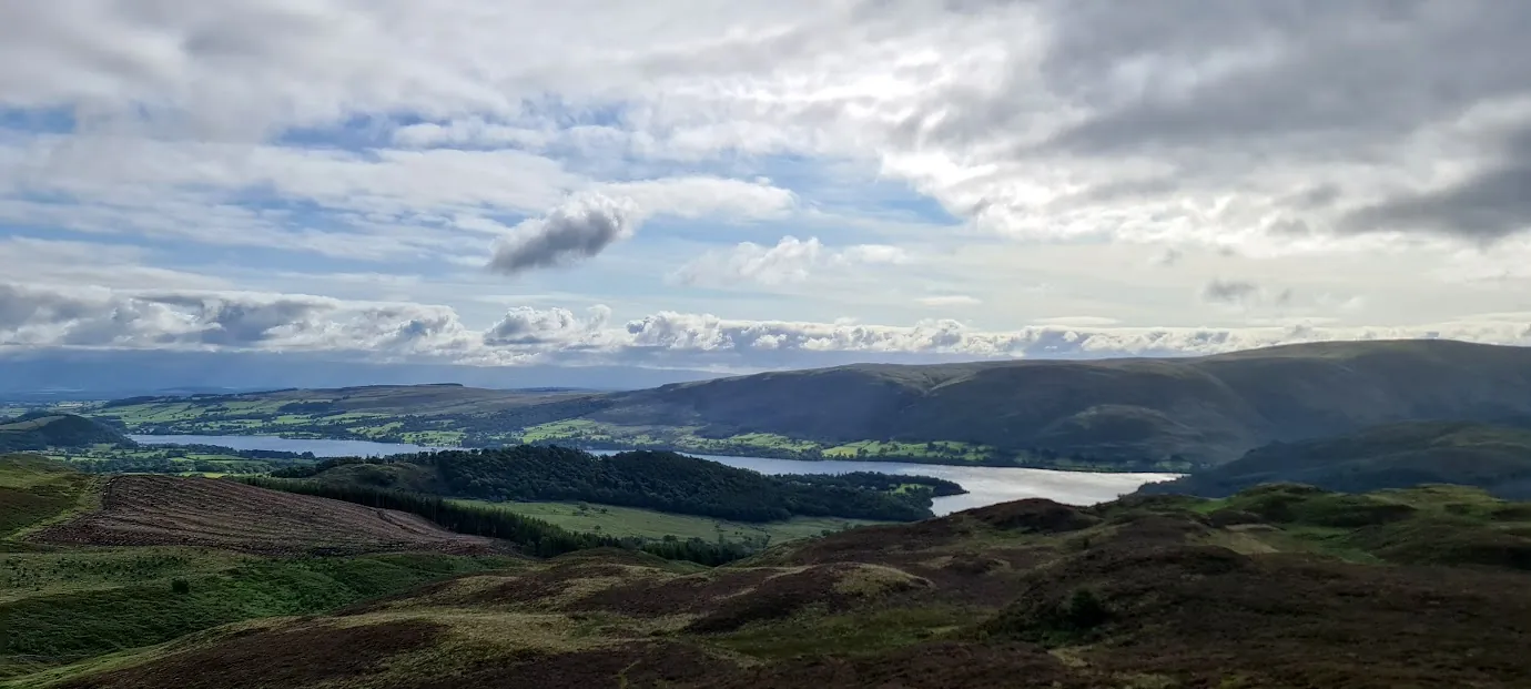
Gowbarrow Fell (Wainwright summit)
Gowbarrow Fell at 481m (1,578ft) rises above the wooded western shores of Ullswater, its open summit giving excellent views of the lake — particularly the middle reach from Howtown to Pooley Bridge.
Is it worth going? — Today’s conditions & 7-day summit forecast
Modelled guidance for the 481 m summit. Always check the Met Office mountain forecast and MWIS before you set off.
On the summit today (Tue 28 Jul): 17° to 14°C, gusts to 34 mph, 1.3 mm of rain forecast.
Forecast snapshot from 28 Jul 2026, 04:58 UTC — refreshed nightly and updated live in your browser. Temperatures and gusts adjusted to the 481 m summit altitude via Open-Meteo. Summit conditions are always harsher than the valley — check the professional mountain forecasts before you go.
About the walk
Gowbarrow Fell (Wainwright summit)
Routes up Gowbarrow Fell (Wainwright summit)
Hand-mapped, with GPX to download — full maps further down.
Map & nearby Birketts
Skip mapFree mapping: OpenTopoMap / OpenStreetMap (switch layers top-right). Parking positions are approximate.
Nearest parking: Aira Force (NT, paid), about 1.6 km from the summit (straight line). Full parking, toilets and bus details are below.
Birketts near Gowbarrow Fell (Wainwright summit) (within 3 km)
These Birkett tops are not Wainwright summits — detour to them on this walk and they are pure profit. Distances are straight-line; allow extra for terrain.
Routes over Gowbarrow Fell (Wainwright summit)
A planned line is a suggestion, not a guarantee — conditions change. Navigate independently and carry a map & compass.
✎️ Planned route — drawn but not personally walked or checked yet.
A planned line is a suggestion, not a guarantee — conditions change. Navigate independently and carry a map & compass.
A planned line is a suggestion, not a guarantee — conditions change. Navigate independently and carry a map & compass.
✎️ Planned route — drawn but not personally walked or checked yet.
A planned line is a suggestion, not a guarantee — conditions change. Navigate independently and carry a map & compass.
The View from Gowbarrow Fell (Wainwright summit)
A computed 360° skyline — every visible named top labelled by distance and bearing, from the terrain model in perfect clarity, not photographed. Drag to pan; reveal the far four-nations horizon.
What you can see from Gowbarrow Fell (Wainwright summit), by direction
- South-east: High Raise (9 km), Low Raise (9 km), Kidsty Pike (10 km)
- South: Gavel Pike (9 km), Rampsgill Head (10 km), High Street (11 km), Hart Crag (11 km), Dove Crag (12 km), Stony Cove Pike (12 km), Thornthwaite Crag (12 km)
- South-west: Birkett Fell (5 km), Hart Side (5 km), Stybarrow Dodd (7 km), Raise (8 km), Catstye Cam (8 km), White Side (9 km), St Sunday Crag (9 km), Helvellyn (9 km), Helvellyn Lower Man (9 km), Nethermost Pike (10 km), High Crag (10 km), Dollywaggon Pike (11 km), Cofa Pike (11 km), Fairfield (11 km), Seat Sandal (12 km), Wetherlam (24 km)
- West: Randerside (6 km), Great Dodd (7 km), Clough Head (7 km), Watson's Dodd (8 km), Skiddaw Lesser Man (15 km)
- North-west: Blencathra (10 km), Gategill Fell Top (10 km), Atkinson Pike (11 km), Knowe Crags (11 km), Skiddaw Little Man (15 km), Skiddaw South Top (16 km), Skiddaw Middle Top (16 km), Skiddaw (16 km), Skiddaw North Top (16 km)
On the clearest days the far horizon adds: Tinto (121 km, Scotland), Wisp Hill (78 km, Scotland), Roan Fell (71 km, Scotland), Cauldcleuch Head (79 km, Scotland), Dun Rig (111 km, Scotland), Pikethaw Hill (76 km, Scotland), Peel Fell (81 km, England), Blackwood Hill (75 km, Scotland).
Computed from terrain in perfect clarity, not photographed · distances are straight-line.
Computed from Copernicus GLO-30 terrain; distant tops from the Database of British and Irish Hills (opens in new tab) (CC BY 4.0). See how we compute the view · and the summit intervisibility report below.
Gowbarrow Fell (Wainwright summit) is one of our picked Lake District viewpoints — what you can see from it, when the light is best, and where to park.
What you can see from Gowbarrow Fell (Wainwright summit)
On a clear day — computed sightlines, curvature- and refraction-corrected.- Great Dun Fell North Pennines
- Cross Fell North Pennines
All 57 Wainwrights in clear view (nearest first)
Little Mell Fell, Hallin Fell, Great Mell Fell, Place Fell, Bonscale Pike, Steel Knotts (Pikeawassa - Steel Knotts), Beda Fell (Beda Head), Glenridding Dodd, Hart Side, Sheffield Pike, Arthur's Pike, Loadpot Hill, Great Dodd, Wether Hill, Arnison Crag, Stybarrow Dodd, The Nab, Birkhouse Moor, Clough Head, Watson's Dodd, Raise, Birks, Catstye Cam, Rest Dodd, White Side, Souther Fell, St Sunday Crag, High Raise (High Street), Helvellyn, Rampsgill Head, The Knott (High Street), Nethermost Pike, Kidsty Pike, Hartsop Above How (Gill Crag - Hartsop Above How), Bannerdale Crags, Blencathra - Hallsfell Top, Gray Crag, Dollywaggon Pike, Fairfield, High Street, Hart Crag, Bowscale Fell, Dove Crag, Stony Cove Pike (Caudale Moor), Thornthwaite Crag, Little Hart Crag (Little Hart Crag - West Top), Seat Sandal, Lonscale Fell, Carrock Fell, Skiddaw Little Man, High Pike (Caldbeck), Skiddaw, Dodd (Skiddaw), Barf, Lord's Seat, Broom Fell, Ling Fell
How Gowbarrow Fell (Wainwright summit)’s view compares with all 214 — the View Report: every Wainwright ranked by what you can see from the top.
Sightlines from a bare-earth terrain model (forests and buildings not included), corrected for the Earth’s curvature and average atmospheric refraction. “Distant” sightlines and any over 100 km depend on exceptionally clear air. Modelled from Copernicus GLO-30 open elevation data — a guide to the view, not a guarantee of any single one.
The path beneath your boots
The gentle path around Gowbarrow didn’t happen by accident. Fix the Fells has repaired it since 2013 — around 570 ranger-days and £114,000 over five years, plus 233 volunteer-days and monthly drain-clearing — rebuilding boggy, widening sections as buried aggregate paths, with stone pitching on the steeper pulls, to protect fragile ground where Grass of Parnassus (Cumbria’s county flower) still grows.
Notice underfoot: the neat stone cross-drains that take water across the path, not down it — please don’t block them, and leave stray stones where they are; they belong in the path.
Fix the Fells built and maintains this path. How a fell path is made → · Give back (opens in new tab)
Path-repair data © Fix the Fells (National Trust / Lake District National Park). Source (opens in new tab).
Best parking to hike Gowbarrow Fell (Wainwright summit)
Where we have the data, each parking spot also shows the nearest public toilets and facilities (cafés, pubs, shops).
Positions are approximate — zoom the map to confirm. Lakeland car parks fill before 9am on fine weekends.
Tip: pan and zoom the interactive map at the top of this page to spot other potential parking near your route.
Water & shelter on the way up
On the Aira Force & Gowbarrow Fell route:
On the Birketts by Gowbarrow route:
On the Gowbarrow Fell and️ Little Mell Fell route:
On the Swineside Knott & Gowbarrow route:
💧 Treat water from the fell before you drink it. A mapped point is usually a tap or public supply, but never drink untreated from a beck, stream or tarn — even clear-looking hill water can carry giardia or cryptosporidium from livestock or a carcass upstream and leave you seriously ill. Run it through a filter or purifier (a LifeStraw, Sawyer Squeeze or HydraPak) or bring it to a rolling boil first.
On-route facilities © OpenStreetMap contributors, per route — an absent marker doesn’t mean none.
Buses to Gowbarrow Fell (Wainwright summit) from Penrith / Ambleside / Windermere
Rural routes change seasonally — confirm on stagecoachbus.com (opens in new tab) or Traveline before relying on a last bus.
My hikes over Gowbarrow Fell (Wainwright summit) (Strava)
1 logged hike pass over this summit:
- A couple more Wainwrights with the kids. (opens in new tab) — 14.5 km · 666 m ascent · 4h 02m moving · 28 Aug 2023
Interactive route maps and photos load here for visitors with JavaScript. Data from Strava.
Hazard & Incident Information for Gowbarrow Fell (Wainwright summit)
A modest, very popular fell above Ullswater, usually climbed via the honeypot waterfall of Aira Force. The fell itself is gentle, but the Aira Force gorge is steep, narrow and slippery, with big unguarded drops where crowds — including children — gather by the falls, and the open fell's paths can be muddy and lost in bracken. The western flank drops steeply to Aira Beck. Patterdale Mountain Rescue Team covers this ground.
- Aira Force gorge & waterfall: Aira Force plunges some 65 ft through a steep, narrow gorge with sheer sides, slippery rock and stone steps, and few natural viewing points or barriers. It's a busy honeypot — keep children and dogs close, stay behind railings and back from wet edges, and don't clamber for a better view of the falls.
- Steep western flank & Yew Crag: The fell's western side drops steeply to Aira Beck, and the pull up by Yew Crag is steep. Keep to the paths and back from the steep edges above the gorge and the beck.
- Bracken-obscured, muddy paths (navigation): On the open fell the path, though signed, can be muddy and hidden by bracken, and easy to lose in cloud. Navigate with a map, watch your footing on ground hidden by bracken, and keep to the line.
Most common causes: Slips and falls in the steep, slippery Aira Force gorge, especially among casual visitors and children · Falls on the steep western flank or near Yew Crag · Navigation errors on bracken-obscured paths in cloud · Wet, slippery rock and steps by the waterfall
Local Mountain Rescue: Patterdale Mountain Rescue Team (opens in new tab) · Reviewed 14 Jun 2026
Safety: Hazard guidance compiled from published Mountain Rescue reports and well-documented accident history - editorial background, not a live feed of callouts. Always check current conditions, carry proper navigation equipment, and seek qualified instruction before heading onto the fells. In an emergency, call 999, ask for Police, then Mountain Rescue.
Navigating Gowbarrow Fell (Wainwright summit) in cloud
StraightforwardA broad, gently-sloping top with little to steer by — easy to lose your bearings and hard to relocate in mist. Navigation here is relatively straightforward even in cloud — but carry map and compass and know how to use them; a low score never means “safe”.
In winter — snow, whiteout, cornices, buried features — every top demands full winter navigation skills whatever its band, and a broad, gentle summit can be the worst place of all. See walking in bad weather and the navigation guide.
How Gowbarrow Fell (Wainwright summit) compares with all 214 — the Clag Index: navigating in cloud. A relative, deliberately cautious guide; the site can’t navigate for you.
Frequently asked questions about Gowbarrow Fell (Wainwright summit)
How difficult is the Gowbarrow Fell walk?
Easy to moderate — 481 m (1,578 ft), on good paths with one steady climb; most walkers manage it comfortably. The classic circuit climbs from the Aira Force woods and returns along the terrace path above Ullswater, one of the finest easy balcony walks in the district.
How long is the Gowbarrow Fell walk?
The circuit with Aira Force takes about 2–3 hours — see our Aira Force & Gowbarrow route. Our longer walked line pairs it with Little Mell Fell for a half-day of about 15 km.
Where do you park for Gowbarrow Fell?
The National Trust Aira Force car parks on the Ullswater road are the usual start (paid, free for NT members) — they fill by mid-morning in season. Park Brow, the smaller NT car park above, is handier for the fell itself. The Ullswater Steamer to Aira Force pier is the car-free option.
Is Gowbarrow Fell a Wainwright, and can you combine it with Aira Force?
Yes on both counts. It's an Eastern Fells Wainwright, and combining it with Aira Force is the natural plan — the waterfall woods are the standard way onto the fell, so you get Lakeland's most famous waterfall and a Wainwright summit in one short round. Dogs manage the round with the odd stile; keep leads on for the deer and sheep.
Questions drawn from real Google “People also ask” searches; answers written and fact-checked by us. · Reviewed 2026-07-20 · Suggest a question or correction (opens in new tab)
Other fells near Gowbarrow Fell (Wainwright summit)
- Arnison Crag
- Birkhouse Moor
- Birks
- Catstye Cam
- Clough Head
- Dollywaggon Pike
- Dove Crag
- Fairfield
- Glenridding Dodd
- Great Dodd
- Great Mell Fell
- Great Rigg
- Hart Crag
- Hart Side
- Hartsop Above How (Gill Crag - Hartsop Above How)
- Helvellyn
- Heron Pike (Rydal)
- High Hartsop Dodd
- High Pike (Scandale)
- Little Hart Crag (Little Hart Crag - West Top)
- Little Mell Fell
- Low Pike
- Middle Dodd
- Nab Scar
- Nethermost Pike
- Raise
- Red Screes
- Seat Sandal
- Sheffield Pike
- St Sunday Crag
- Stone Arthur
- Stybarrow Dodd
- Watson's Dodd
- White Side
Maps & guidebooks for Gowbarrow Fell (Wainwright summit)
- Buy on Amazon (opens in new tab)
- Buy on Amazon (opens in new tab)
- Buy on Amazon (opens in new tab)
- Buy on Amazon (opens in new tab)
- Buy on Amazon (opens in new tab)
As an Amazon Associate we earn from qualifying purchases — at no extra cost to you. How affiliate links work →