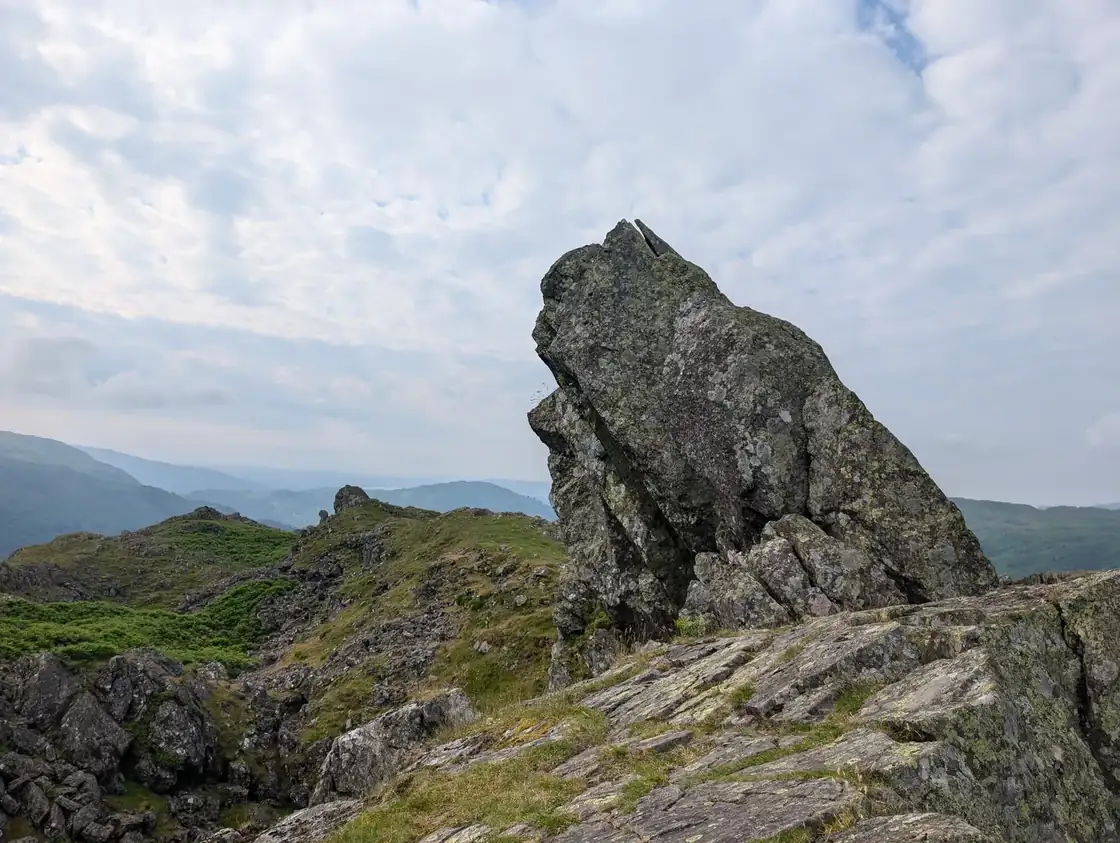
Helm Crag
Helm Crag at 405m (1,329ft) is one of the most famous and distinctive summits in Lakeland — the jagged, rocky outline known as 'The Lion and the Lamb' visible from Grasmere below.
Is it worth going? — Today’s conditions & 7-day summit forecast
Modelled guidance for the 405 m summit. Always check the Met Office mountain forecast and MWIS before you set off.
On the summit today (Tue 28 Jul): 17° to 15°C, gusts to 29 mph, 9.1 mm of rain forecast.
Forecast snapshot from 28 Jul 2026, 04:58 UTC — refreshed nightly and updated live in your browser. Temperatures and gusts adjusted to the 405 m summit altitude via Open-Meteo. Summit conditions are always harsher than the valley — check the professional mountain forecasts before you go.
About the walk
Helm Crag
Short version: Helm Crag is a short, steep, straightforward walk — and the scramble everyone worries about is optional. It is only 405 m, and the there-and-back from Grasmere takes most people about 2–3 hours on firm, well-used paths. The pull out of the village is steep and unrelenting, and the summit crest is rocky and knobbly with narrow lines between the outcrops, so it wants proper footwear and care with footing when the rock is wet. As a hill walk, though, it suits anyone reasonably fit — including families used to a bit of steepness.
You do not have to climb the Howitzer. The true summit is that last rock pinnacle — the one that makes the famous skyline — and standing on the very top of it needs a short but genuinely exposed scramble with big drops beneath, awkward to reverse once you are up. Most walkers stop at its foot, and for almost everyone that is walking Helm Crag: you have had the fell, the views down Grasmere, and the rocks themselves. I’ve been up Helm Crag twice — once in the heat of June 2024, once in a much colder January 2025 — and haven’t stood on top of the pinnacle either time. Save the pinnacle for a dry day and a confident head, and never feel pushed onto it by the people ahead of you. Those same rocks, seen end-on from the village below, are the Lion and the Lamb — the name most people know the fell by. For a longer day, the Helm Crag & Far Easedale round extends it into a full horseshoe of about 16 km.
Routes up Helm Crag
Hand-mapped, with GPX to download — full maps further down.
Map & nearby Birketts
Skip mapFree mapping: OpenTopoMap / OpenStreetMap (switch layers top-right). Parking positions are approximate.
Nearest parking: Grasmere village (paid), about 2.2 km from the summit (straight line). Full parking, toilets and bus details are below.
Birketts near Helm Crag (within 3 km)
These Birkett tops are not Wainwright summits — detour to them on this walk and they are pure profit. Distances are straight-line; allow extra for terrain.
Routes over Helm Crag
A planned line is a suggestion, not a guarantee — conditions change. Navigate independently and carry a map & compass.
A planned line is a suggestion, not a guarantee — conditions change. Navigate independently and carry a map & compass.
The View from Helm Crag
A computed 360° skyline — every visible named top labelled by distance and bearing, from the terrain model in perfect clarity, not photographed. Drag to pan; reveal the far four-nations horizon.
What you can see from Helm Crag, by direction
- North: High Crag (5 km), Helvellyn (6 km), Helvellyn Lower Man (6 km), Knowe Crags (18 km), Gategill Fell Top (18 km), Knott (24 km)
- North-east: Seat Sandal (3 km), Fairfield (4 km), Dollywaggon Pike (4 km)
- East: Great Rigg (3 km), Heron Pike North Top (3 km), Heron Pike (3 km)
- South-east: Nab Scar (4 km), Wansfell Pike (8 km)
- South-west: Castle How (3 km), Blea Rigg (3 km), Harrison Stickle (5 km), Thorn Crag (5 km), Pike of Blisco (8 km), Great Knott (8 km), Crinkle Crags (9 km), Shelter Crags (9 km), Crinkle Crags (9 km), Crinkle Crags (9 km), Crinkle Crags (9 km), Crinkle Crags South Top (9 km), Wetherlam (9 km), Black Sails (10 km), Little Carrs (10 km), Little Stand (10 km), Great Carrs (10 km), Swirl How (10 km), Great How (11 km), Grey Friar (11 km), Dow Crag (13 km)
- West: Codale Head (4 km), Sergeant Man (4 km), Pavey Ark (4 km), Low White Stones (4 km), Thunacar Knott (5 km)
On the clearest days the far horizon adds: Cadair Berwyn (179 km, Wales), Winter Hill (100 km, England), Penycloddiau (143 km, Wales).
Computed from terrain in perfect clarity, not photographed · distances are straight-line.
Computed from Copernicus GLO-30 terrain; distant tops from the Database of British and Irish Hills (opens in new tab) (CC BY 4.0). See how we compute the view · and the summit intervisibility report below.
Helm Crag is one of our picked Lake District viewpoints — what you can see from it, when the light is best, and where to park.
What you can see from Helm Crag
On a clear day — computed sightlines, curvature- and refraction-corrected.- Ingleborough Yorkshire Dales
All 28 Wainwrights in clear view (nearest first)
Gibson Knott, Steel Fell (Dead Pike - Steel Fell), Stone Arthur, Tarn Crag (Easedale), Calf Crag, Silver How, Seat Sandal, Blea Rigg, Great Rigg, Heron Pike (Rydal), Nab Scar, Fairfield, Sergeant Man, Dollywaggon Pike, Pavey Ark, Loughrigg Fell, Harrison Stickle, Thunacar Knott, Lingmoor Fell (Brown How), Helvellyn, Pike of Blisco, Black Fell, Crinkle Crags - Long Top (Second Crinkle), Wetherlam, Great Carrs, Swirl How, Grey Friar, Dow Crag
How Helm Crag’s view compares with all 214 — the View Report: every Wainwright ranked by what you can see from the top.
Sightlines from a bare-earth terrain model (forests and buildings not included), corrected for the Earth’s curvature and average atmospheric refraction. “Distant” sightlines and any over 100 km depend on exceptionally clear air. Modelled from Copernicus GLO-30 open elevation data — a guide to the view, not a guarantee of any single one.
Best parking to hike Helm Crag
Where we have the data, each parking spot also shows the nearest public toilets and facilities (cafés, pubs, shops).
Positions are approximate — zoom the map to confirm. Lakeland car parks fill before 9am on fine weekends.
Tip: pan and zoom the interactive map at the top of this page to spot other potential parking near your route.
Water & shelter on the way up
On the Helm Crag & Far Easedale route:
On the Helm Crag, Gibson Knott, Calf Crag, Steel Fell and Tarn Crag route:
On-route facilities © OpenStreetMap contributors, per route — an absent marker doesn’t mean none.
Buses to Helm Crag from Penrith / Ambleside / Windermere
Rural routes change seasonally — confirm on stagecoachbus.com (opens in new tab) or Traveline before relying on a last bus.
My hikes over Helm Crag (Strava)
2 logged hikes pass over this summit:
- Redoing Steel Fell, Calf Crag, Gibson Knott and Helm Crag. 38c cooler this time (opens in new tab) — 14.1 km · 699 m ascent · 4h 14m moving · 19 Jan 2025
- That was a bit warm. 29c at the summit of Steel Fell!! (opens in new tab) — 20.4 km · 1005 m ascent · 5h 39m moving · 26 Jun 2024
Interactive route maps and photos load here for visitors with JavaScript. Data from Strava.
Hazard & Incident Information for Helm Crag
The famous 'Lion and the Lamb' above Grasmere — a small, very popular fell with a rocky, knobbly crest. Its true summit is an airy 20-foot rock pinnacle (the 'Howitzer') reached only by an exposed scramble that Wainwright himself never completed; most walkers stop just short. The combination of a tempting scramble, steep drops and many casual visitors is the catch. Langdale Ambleside Mountain Rescue Team covers this ground.
- The summit rock (the Howitzer): The actual highest point is a slab/pinnacle of rock needing a short but genuinely exposed scramble, with big drops below. It is not for the nervous or inexperienced — many people sensibly admire it from beside rather than standing on top. Attempt it only if you are a confident scrambler and the rock is dry; a slip here would be serious.
- Rocky crest, loose rock & steep drops: The summit ridge is rocky and knobbly with narrow paths, loose rock and steep ground falling toward the A591. Take care with footing along the crest, especially when wet, and keep back from the edges.
- A popular fell for casual walkers: Helm Crag draws many first-time and family walkers up its short, steep paths. Wear proper footwear, don't be pressured onto the summit scramble, and treat the rocky ground with the respect a 'small' fell can still demand.
Most common causes: Falls attempting the exposed summit pinnacle scramble · Slips on loose rock and the narrow rocky crest, especially when wet · Casual walkers underestimating the steep, rocky ground · Winter ice on the summit rocks and crest
Local Mountain Rescue: Langdale Ambleside Mountain Rescue Team (opens in new tab) · Reviewed 14 Jun 2026
Safety: Hazard guidance compiled from published Mountain Rescue reports and well-documented accident history - editorial background, not a live feed of callouts. Always check current conditions, carry proper navigation equipment, and seek qualified instruction before heading onto the fells. In an emergency, call 999, ask for Police, then Mountain Rescue.
Navigating Helm Crag in cloud
StraightforwardA broad, gently-sloping top with little to steer by — easy to lose your bearings and hard to relocate in mist. Navigation here is relatively straightforward even in cloud — but carry map and compass and know how to use them; a low score never means “safe”.
In winter — snow, whiteout, cornices, buried features — every top demands full winter navigation skills whatever its band, and a broad, gentle summit can be the worst place of all. See walking in bad weather and the navigation guide.
How Helm Crag compares with all 214 — the Clag Index: navigating in cloud. A relative, deliberately cautious guide; the site can’t navigate for you.
Frequently asked questions about Helm Crag
Why is Helm Crag called the Lion and the Lamb?
The summit of Helm Crag is crowned by dramatic rock outcrops that, seen from Grasmere village, look like a lion lying beside a lamb — hence the famous nickname. It's one of the most recognised and photographed fell tops in the Lakes.
The same rocks take on other shapes from different angles: from Dunmail Raise they resemble a cannon (the 'Howitzer'), and from Mill Gill 'the Old Woman playing the organ' — all on the same little summit.
Can you actually stand on the summit of Helm Crag?
Most walkers don't reach the true top. The actual highest point is the tip of the 'Howitzer' rock, and standing on it needs a short but genuinely exposed rock climb — Wainwright himself famously never managed it, and wrote that hardly anyone reaches the very summit.
You can walk to the foot of the summit rocks easily and enjoy the same views; only confident, experienced scramblers should attempt the airy move onto the top itself, and never when it's wet.
Is Helm Crag a hard walk?
No — Helm Crag (405 m / 1,329 ft) is a short, steep but straightforward walk on a good, restored path, ideal when you only have a few hours. There's no scrambling unless you choose to tackle the summit rock itself.
It's steep enough to get the heart going, but its modest height and well-made path make it one of the most rewarding little fells in the area.
What is the route up Helm Crag, and how long does it take?
The usual route starts in Grasmere, heading up the lane past Lancrigg and onto the clear, stone-pitched path that climbs the south-east ridge to the summit rocks. Out and back it's roughly 4 km with about 330 m of ascent, taking 2–3 hours.
For a longer day you can continue along the ridge over Gibson Knott and Calf Crag and return down Far Easedale.
Sources: Live for the Outdoors — Helm Crag walking route (opens in new tab)
Is Helm Crag good for families and children?
It's an excellent family fell — short, with a clear path, a real summit feel and the fun of the lion-and-lamb rocks to aim for, all for modest effort. Children love scrambling around the boulders at the top.
Keep little ones close among the summit outcrops, where there are steep drops, and don't let anyone try to climb the exposed Howitzer rock. Pick a dry, clear day and dress for the breezy top.
Where do you park for Helm Crag?
Park in Grasmere village, which has several pay-and-display car parks, then walk out along Easedale Road and the lane to the foot of the fell. There's no parking at the start of the path itself.
Grasmere is busy and its car parks fill quickly in season, so arrive early or use the village as part of a longer round.
Sources: The Young Rambler — Helm Crag hiking guide (opens in new tab)
What should I wear and take up Helm Crag?
Sturdy walking shoes or boots with good grip are fine on the well-made path; boots help if you'll scramble among the summit rocks. Take a waterproof and a warm layer — even this low top is cooler and breezier than Grasmere — plus water and a snack.
Check the forecast, keep away from the steep drops around the summit outcrops, and leave the exposed Howitzer rock alone unless you're an experienced scrambler on a dry day.
Questions drawn from real Google “People also ask” searches; answers written and fact-checked by us. · Reviewed 2026-06-15 · Suggest a question or correction (opens in new tab)
Other fells near Helm Crag
- Armboth Fell (Armboth Fell South Top)
- Blea Rigg
- Bleaberry Fell
- Calf Crag
- Eagle Crag
- Gibson Knott
- Grange Fell (Brund Fell)
- Great Crag (Stonethwaite)
- Harrison Stickle
- High Raise (High White Stones)
- High Rigg (Naddle Fell)
- High Seat
- High Tove
- Loft Crag
- Loughrigg Fell
- Pavey Ark
- Pike of Stickle
- Raven Crag
- Sergeant Man
- Sergeant's Crag
- Silver How
- Steel Fell (Dead Pike - Steel Fell)
- Tarn Crag (Easedale)
- Thunacar Knott
- Ullscarf
- Walla Crag
Maps & guidebooks for Helm Crag
- Buy on Amazon (opens in new tab)
- Buy on Amazon (opens in new tab)
- Buy on Amazon (opens in new tab)
- Buy on Amazon (opens in new tab)
- Buy on Amazon (opens in new tab)
As an Amazon Associate we earn from qualifying purchases — at no extra cost to you. How affiliate links work →