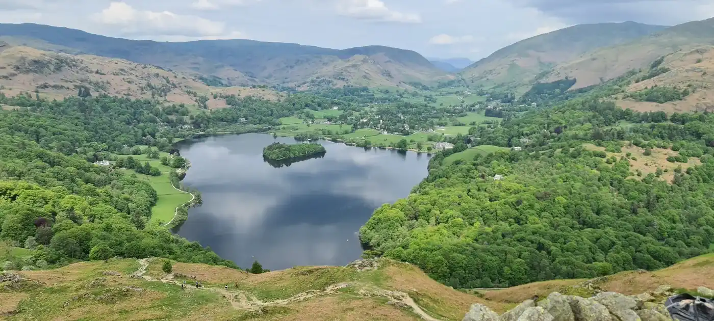
Loughrigg Fell
Loughrigg Fell at 335m (1,099ft) is one of the most beloved and visited fells in the Lake District, a complex heathery mass rising between Ambleside, Grasmere and Elterwater.
Is it worth going? — Today’s conditions & 7-day summit forecast
Modelled guidance for the 335 m summit. Always check the Met Office mountain forecast and MWIS before you set off.
On the summit today (Tue 28 Jul): 17° to 15°C, gusts to 27 mph, 9.9 mm of rain forecast.
Forecast snapshot from 28 Jul 2026, 04:58 UTC — refreshed nightly and updated live in your browser. Temperatures and gusts adjusted to the 335 m summit altitude via Open-Meteo. Summit conditions are always harsher than the valley — check the professional mountain forecasts before you go.
About the walk
Loughrigg Fell
- How hard
- no, Loughrigg is not a hard walk — but it is not the pushover its height suggests either.
- How long
- ~2–2.5 h
- Height
- 335 m (1,099 ft)
Short version: no, Loughrigg is not a hard walk — but it is not the pushover its height suggests either. At 335 m it is one of the lowest Wainwrights, there is no scrambling and no exposure worth the name, and most people are up and back in about 2 hours from Ambleside or White Moss. As a first Wainwright it is a good one.
The sting is the top, not the climb. Loughrigg’s summit area is a maze of little knolls, boggy hollows and criss-crossing paths, and it genuinely disorientates people in low cloud — there are several false tops, and the many junctions make it easy to start down the wrong path and end up in the wrong valley. This is a fell where people get turned around far more often than they get hurt. Expect wet feet, too: we rate it 0.6 for bogginess, high for a fell this size. On a clear day none of that matters; in mist, take a bearing off the top like you would on anything bigger.
The full round — the classic circuit from Ambleside over Todd Crag and Lily Tarn, across the summit and back past Rydal Cave — is 10.4 km with 392 m of ascent, so roughly 2¾–3½ hours at a steady pace rather than the 2 hours of the there-and-back. That route is walked by Lee July 2026.
One thing worth knowing about Rydal Cave, since most circuits pass it: it is a disused slate quarry cavern, not a natural cave. Blocks occasionally fall from the ceiling, the stepping stones at the entrance get slippery, and the floor floods after rain. Fine to look into, worth not lingering under. And yes — Loughrigg Fell is a Wainwright, in the Central Fells.
Routes up Loughrigg Fell
Hand-mapped, with GPX to download — full maps further down.
Map & nearby Birketts
Skip mapFree mapping: OpenTopoMap / OpenStreetMap (switch layers top-right). Parking positions are approximate.
Nearest parking: White Moss (paid), about 1.2 km from the summit (straight line). Full parking, toilets and bus details are below.
Birketts near Loughrigg Fell (within 3 km)
No bonus Birketts within 3 km — every Birkett near here is already a Wainwright summit, so just enjoy the walk.
Routes over Loughrigg Fell
A planned line is a suggestion, not a guarantee — conditions change. Navigate independently and carry a map & compass.
✎️ Bags Loughrigg Fell (335 m) — a summit with a view far bigger than its height suggests.
✎️ Planned route — drawn but not personally walked or checked yet.
A planned line is a suggestion, not a guarantee — conditions change. Navigate independently and carry a map & compass.
The View from Loughrigg Fell
A computed 360° skyline — every visible named top labelled by distance and bearing, from the terrain model in perfect clarity, not photographed. Drag to pan; reveal the far four-nations horizon.
What you can see from Loughrigg Fell, by direction
- North: Great Rigg (5 km), Seat Sandal (6 km), Hart Crag (6 km), Fairfield (7 km), Dollywaggon Pike (8 km), High Crag (8 km), Lonscale Fell (23 km), Lonscale Pike (23 km), Jenkin Hill (24 km), Skiddaw Lesser Man (24 km), Skiddaw Little Man (24 km), Skiddaw South Top (25 km), Skiddaw Middle Top (25 km), Skiddaw (26 km), Skiddaw North Top (26 km)
- North-east: Dove Crag (6 km)
- East: Yoke (9 km), Ill Bell (9 km), Froswick (10 km)
- South-west: Wetherlam (7 km), Swirl How (9 km), Great Carrs (9 km), Brim Fell (10 km), The Old Man of Coniston (10 km)
- West: Harrison Stickle (7 km), Pike of Blisco (8 km), Crinkle Crags (10 km), Crinkle Crags South Top (10 km), Crinkle Crags (10 km), Crinkle Crags (10 km), Shelter Crags (10 km), Crinkle Crags (10 km), Bowfell (10 km), Esk Pike (11 km), Great End (12 km), Scafell (14 km)
- North-west: Codale Head (7 km), Sergeant Man (7 km), Thunacar Knott (7 km), Ullscarf (9 km)
On the clearest days the far horizon adds: Snowdon (168 km, Wales), Carnedd Llewelyn (156 km, Wales), Moel y Gamelin (160 km, Wales), Moel Famau (144 km, Wales), Moel Eilio (167 km, Wales), Y Garn (162 km, Wales), Cyrn-y-Brain (157 km, Wales), Penycloddiau (139 km, Wales).
Computed from terrain in perfect clarity, not photographed · distances are straight-line.
Computed from Copernicus GLO-30 terrain; distant tops from the Database of British and Irish Hills (opens in new tab) (CC BY 4.0). See how we compute the view · and the summit intervisibility report below.
Loughrigg Fell is one of our picked Lake District viewpoints — what you can see from it, when the light is best, and where to park.
What you can see from Loughrigg Fell
On a clear day — computed sightlines, curvature- and refraction-corrected.On the clearest days the view reaches across to Wales.
- Snowdon (Yr Wyddfa) Wales
- Ingleborough Yorkshire Dales
- Whernside Yorkshire Dales
All 49 Wainwrights in clear view (nearest first)
Nab Scar, Silver How, Heron Pike (Rydal), Black Fell, Low Pike, Stone Arthur, Lingmoor Fell (Brown How), High Pike (Scandale), Helm Crag, Great Rigg, Blea Rigg, Holme Fell, Baystones (Wansfell), Gibson Knott, Dove Crag, Tarn Crag (Easedale), Seat Sandal, Hart Crag, Steel Fell (Dead Pike - Steel Fell), Fairfield, Pavey Ark, Harrison Stickle, Calf Crag, Wetherlam, Sergeant Man, Loft Crag, Thunacar Knott, Pike of Stickle, Pike of Blisco, Dollywaggon Pike, Cold Pike, Swirl How, Great Carrs, Ullscarf, Yoke, Ill Bell, Froswick, Crinkle Crags - Long Top (Second Crinkle), Brim Fell, Rossett Pike, Bowfell, The Old Man of Coniston (Coniston Old Man), Esk Pike, Great End, Scafell, Raven Crag, Lonscale Fell, Skiddaw Little Man, Skiddaw
How Loughrigg Fell’s view compares with all 214 — the View Report: every Wainwright ranked by what you can see from the top.
Sightlines from a bare-earth terrain model (forests and buildings not included), corrected for the Earth’s curvature and average atmospheric refraction. “Distant” sightlines and any over 100 km depend on exceptionally clear air. Modelled from Copernicus GLO-30 open elevation data — a guide to the view, not a guarantee of any single one.
Best parking to hike Loughrigg Fell
Where we have the data, each parking spot also shows the nearest public toilets and facilities (cafés, pubs, shops).
Positions are approximate — zoom the map to confirm. Lakeland car parks fill before 9am on fine weekends.
Tip: pan and zoom the interactive map at the top of this page to spot other potential parking near your route.
Water & shelter on the way up
On the Ambleside, Todd Crag, Rydal Cave route:
On the Loughrigg Tarn & Loughrigg Fell route:
On-route facilities © OpenStreetMap contributors, per route — an absent marker doesn’t mean none.
Buses to Loughrigg Fell from Penrith / Ambleside / Windermere
Rural routes change seasonally — confirm on stagecoachbus.com (opens in new tab) or Traveline before relying on a last bus.
My hikes over Loughrigg Fell (Strava)
1 logged hike pass over this summit:
- Hike with Henry (opens in new tab) — 10.7 km · 418 m ascent · 2h 57m moving · 21 May 2023
Interactive route maps and photos load here for visitors with JavaScript. Data from Strava.
Hazard & Incident Information for Loughrigg Fell
A low, hugely popular fell ringed by Ambleside, Rydal and Grasmere — gentle and family-friendly, but with a surprising sting: its top is a maze of little knolls, boggy hollows and criss-crossing paths that genuinely disorientates people in low cloud, and on descent it's easy to take the wrong path into the wrong valley. The old quarry cavern of Rydal Cave on its flank adds a rockfall risk. It draws many first-time and casual walkers, so the navigation catch matters. Langdale Ambleside Mountain Rescue Team covers this ground.
- Maze of knolls, paths & bog (navigation): Despite its modest size, the summit area is a confusing tangle of knolls, boggy puddles and minor paths, and the many junctions on descent are easy to muddle — people end up heading to the wrong town. In low cloud you need map and compass; don't assume a small popular fell can't catch you out.
- Rydal Cave (rockfall): Rydal Cave is a disused slate quarry cavern; blocks occasionally fall from the ceiling, the stepping stones at the entrance are slippery, and the floor floods. Admire it without lingering under the roof, and take care on the wet stones.
- Small crags & quarry edges on the flanks: Old quarry workings and small crags dot the fell's sides. Keep to the paths rather than cutting across steep or quarried ground, especially with children or in poor light.
Most common causes: Navigation errors and wrong-valley descents from the maze of paths in cloud · Slips on boggy ground and the wet stepping stones at Rydal Cave · Rockfall inside Rydal Cave · Casual walkers underestimating a small but confusing fell
Local Mountain Rescue: Langdale Ambleside Mountain Rescue Team (opens in new tab) · Reviewed 14 Jun 2026
Safety: Hazard guidance compiled from published Mountain Rescue reports and well-documented accident history - editorial background, not a live feed of callouts. Always check current conditions, carry proper navigation equipment, and seek qualified instruction before heading onto the fells. In an emergency, call 999, ask for Police, then Mountain Rescue.
Navigating Loughrigg Fell in cloud
StraightforwardA broad, gently-sloping top with little to steer by — easy to lose your bearings and hard to relocate in mist. Navigation here is relatively straightforward even in cloud — but carry map and compass and know how to use them; a low score never means “safe”.
In winter — snow, whiteout, cornices, buried features — every top demands full winter navigation skills whatever its band, and a broad, gentle summit can be the worst place of all. See walking in bad weather and the navigation guide.
How Loughrigg Fell compares with all 214 — the Clag Index: navigating in cloud. A relative, deliberately cautious guide; the site can’t navigate for you.
Frequently asked questions about Loughrigg Fell
Is Loughrigg Fell hard to climb?
No — it's one of the easiest 'big-view' fells in the Lakes. At just 335 m (1,099 ft), ringed by Ambleside, Grasmere and Rydal, it's a short climb on good paths with no scrambling on the standard routes, ideal for walkers of all abilities.
Its one surprise is navigation: the top is a confusing maze of little knolls and criss-crossing paths, so it's easy to wander in cloud despite the modest size.
Sources: Langdale Ambleside Mountain Rescue Team (opens in new tab)
What is the easiest route up Loughrigg Fell?
There are short, easy starts from Ambleside, Grasmere, Rydal and White Moss. From Rydal it's about 6.5 km; from Ambleside a popular round goes over the top and along Loughrigg Terrace, with the option of Rydal Cave.
All are on good paths — just note some variants include short, steep rock steps, so keep to the main path if you want the gentlest line.
How long does it take to walk Loughrigg Fell?
A there-and-back from Ambleside, Grasmere or Rydal takes around 2–3 hours. A fuller circular taking in Loughrigg Terrace and Rydal Cave is about 10 km and 3.5–4 hours.
Is Loughrigg Fell good for families and dogs?
Yes — it's a favourite family and dog walk, short and scenic with huge views for modest effort. Most active children and dogs manage it easily.
Two cautions: some route variants have steep rock steps that aren't ideal for very small children or small dogs (keep to the main path), and there are old quarry holes and small crags about, so keep little ones close. Keep dogs on a lead around grazing sheep.
Sources: Langdale Ambleside Mountain Rescue Team (opens in new tab)
Is Rydal Cave on Loughrigg worth visiting, and is it safe?
It's a popular, atmospheric stop — a large man-made cavern left by 19th-century slate quarrying, reached by stepping stones across a shallow pool. Worth the short detour for most walkers.
Take care, though: blocks occasionally fall from the roof, so don't linger directly underneath, and the stepping stones and floor are slippery and can flood. Keep children supervised inside.
Is it easy to get lost on Loughrigg Fell?
Surprisingly, yes — for such a small fell, the summit is a maze of knolls, boggy hollows and minor paths, and on descent the many junctions make it easy to head down to the wrong town. This is the main thing to watch.
Carry a map (and a compass for cloud), and pick your path junctions carefully so you come down where you intend. Don't assume a small popular fell can't catch you out in mist.
Sources: Langdale Ambleside Mountain Rescue Team (opens in new tab)
What should I wear and take up Loughrigg Fell?
Sturdy trainers or walking shoes with grip are fine for this low fell, with a waterproof and warm layer as the top is breezier than the valley. Take a map (the maze of paths makes one genuinely useful), water and a snack.
Mind the boggy patches and the slippery stepping stones at Rydal Cave, and in winter watch for icy rock steps even on this gentle hill.
Questions drawn from real Google “People also ask” searches; answers written and fact-checked by us. · Reviewed 2026-06-14 · Suggest a question or correction (opens in new tab)
Other fells near Loughrigg Fell
- Armboth Fell (Armboth Fell South Top)
- Blea Rigg
- Bleaberry Fell
- Calf Crag
- Eagle Crag
- Gibson Knott
- Grange Fell (Brund Fell)
- Great Crag (Stonethwaite)
- Harrison Stickle
- Helm Crag
- High Raise (High White Stones)
- High Rigg (Naddle Fell)
- High Seat
- High Tove
- Loft Crag
- Pavey Ark
- Pike of Stickle
- Raven Crag
- Sergeant Man
- Sergeant's Crag
- Silver How
- Steel Fell (Dead Pike - Steel Fell)
- Tarn Crag (Easedale)
- Thunacar Knott
- Ullscarf
- Walla Crag
Maps & guidebooks for Loughrigg Fell
- Buy on Amazon (opens in new tab)
- Buy on Amazon (opens in new tab)
- Buy on Amazon (opens in new tab)
- Buy on Amazon (opens in new tab)
- Buy on Amazon (opens in new tab)
As an Amazon Associate we earn from qualifying purchases — at no extra cost to you. How affiliate links work →