Skelwith Force
Getting there, parking, where to stay and the fells you can walk straight from Skelwith Force.
Skelwith Force at a glance
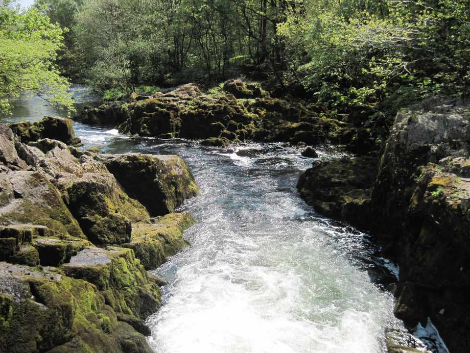
Skelwith Force is a waterfall famous for power, not height: it's only a low drop, but it carries the whole River Brathay draining Great Langdale and Elter Water, so after rain it's a genuinely thunderous rush of white water — one of the biggest volumes of any fall in the Lakes. It sits just below Skelwith Bridge, reached by a short, near-level riverside path, which makes it one of the most accessible waterfalls in the District and a favourite easy walk from Elterwater.
Quick facts
| What it is | A low but very powerful waterfall on the River Brathay, below Skelwith Bridge |
| The walk | A short, fairly level riverside stroll from Skelwith Bridge (~½ mile) — part of the classic Elterwater loop |
| Can you swim? | Not at the force — it's powerful and rocky; the quiet Elter Water just upstream is the place |
| Dogs | Welcome — an easy, popular dog walk (lead near the road and the fall) |
| Pushchair / family | Part-buggy — the riverside path is mostly level, with a rougher, rockier stretch at the fall itself |
| Getting there | Skelwith Bridge (Chesters café / Kirkstone Galleries) on the A593; or walk in from Elterwater |
| Best time | After heavy rain, when the volume is astonishing; any season for the easy walk |
| The fell above | Loughrigg Fell — the low, view-rich fell between here and Grasmere |
Where is Skelwith Force?
Skelwith Force near Skelwith Bridge, in the Lake District. Zoom and pan to explore — or see every Lake District waterfall on one map.
The walk to the falls
This is one of the easiest waterfalls to reach in the Lakes. From Skelwith Bridge — where there's a café and the Kirkstone slate gallery — a broad, near-level path follows the River Brathay downstream for about half a mile to the force; only the last short stretch, out onto the rocks by the fall, is rougher underfoot. Most people make it part of the classic loop from Elterwater: along Elter Water, down to Skelwith Force, and back — a gentle few miles with a café at each end. For a bigger day, Colwith Force lies a little further up the Brathay, and Loughrigg Fell rises just to the north.
Swimming
Skelwith Force itself is not a swimming spot — it's a low, ferociously powerful chute over rock, and the volume of water pouring through makes it genuinely dangerous to enter, especially after rain. Admire it from the bank. If you want a dip nearby, Elter Water just upstream is calm and lovely, and Loughrigg Tarn is close by too. As anywhere, open water is cold all year — get in slowly and know the signs of cold-water shock.
When to go
Skelwith Force is all about volume, so it's at its jaw-dropping best after heavy rain, when the whole of Langdale's water funnels through in a roaring surge you can feel as much as see. In a dry spell it's gentler but still worth the easy stroll. Because the walk is so accessible it can be busy on fine weekends; an early or off-season visit gives you the riverside more to yourself, and autumn lights up the woods along the Brathay.
The setting
The force sits in gentle, wooded country where Great Langdale's river slows towards Elter Water and Windermere — a soft, green landscape of riverside meadow and slate, very different from the high fell ravines. Skelwith Bridge itself has long been a working slate place (the Kirkstone Galleries continue the tradition), and the easy path, the café and the flat going have made this a beloved family and dog walk for generations. It's the low-level Lakeland of Elter Water and Loughrigg, all within an easy stroll.
The name & its story
"Skelwith" is Old Norse and means, appropriately, the "resounding ford" — from skjallr (loud, resounding) and vath (a ford) — a name earned by the roar of the very falls beside the old crossing. "Force", as ever in the Lakes, is the Norse fors, a waterfall. So the name is a thousand-year-old description of exactly what you come to see and hear: the loud water by the ford.
Family, dogs & accessibility
Skelwith Force is about as family- and dog-friendly as a Lakeland waterfall gets: a short, mostly level riverside path from Skelwith Bridge, with cafes and toilets at hand. It's part-buggy — the main path is easy, but the final stretch out onto the rocks by the fall is uneven, so you may go the last few metres on foot. Dogs love it; keep them on a lead near the A593 at the bridge and near the powerful water. It's an ideal easy outing for little legs and a gentle introduction to the Lakes' waterfalls.
The fell above
Rising just to the north is Loughrigg Fell, a low, rambling fell packed with views over Windermere, Elter Water and the Langdale Pikes — a natural extension if you want to turn the easy waterfall walk into a proper half-day. The gentle circuit of Elter Water and the walk on to Colwith Force are the other obvious add-ons.
Getting there & parking
The nearest parking is at Skelwith Bridge on the A593 (Ambleside–Coniston road), by the Chesters café and Kirkstone Galleries; it's limited, so arrive early, or use the Elterwater car parks and walk in along the river. It's an easy car-free trip too: the seasonal Langdale Rambler (516) bus runs up the valley from Ambleside and stops nearby, so you can reach this gentle waterfall without a car.
Fells & walks near Skelwith Force
Straight-line distances from the centre of Skelwith Force — the nearest summits with a full guide on this site.
All walks from Skelwith Force → — every route and fell within about 5 km, ranked, with today’s conditions.
Events & festivals
Planning a trip around a show or festival? See our Lake District events & festivals guide for what's on near Skelwith Force — traditional Lakeland sports, agricultural shows and seasonal events, month by month.
Frequently asked questions about Skelwith Force
Where do you park for Skelwith Force?
The nearest parking is at Skelwith Bridge on the A593 (by the Chesters cafe and the Kirkstone Galleries slate shop), but it's limited, so arrive early. Many people instead use the Elterwater car parks and walk in along the river — a lovely, near-level stroll of about half a mile to the force. The seasonal Langdale Rambler (516) bus also stops nearby.
What makes Skelwith Force special?
Not its height — it's a low fall — but its power. Skelwith Force carries the whole River Brathay draining Great Langdale and Elter Water, so after rain it's a genuinely thunderous rush, with one of the largest volumes of water of any Lakeland waterfall. Add an easy, near-level riverside walk and cafes at Skelwith Bridge, and it's one of the most accessible and rewarding short waterfall outings in the Lakes.
How long is the Skelwith Force walk?
It's very short from Skelwith Bridge — about half a mile of mostly level riverside path to the fall, so 15–20 minutes at a gentle pace. Most people make it part of the classic Elterwater loop (along Elter Water, down to the force and back), a gentle few-mile circuit with a cafe at each end.
Is Skelwith Force suitable for kids and pushchairs?
It's excellent for families — short, easy and dramatic. The riverside path is mostly level, so it's part-buggy: you can push most of the way, though the final stretch out onto the rocks by the fall is uneven, so you may do the last few metres on foot. Keep children (and dogs) close to the powerful water.
Can you swim at Skelwith Force?
Not at the force itself — it's a low but ferociously powerful chute over rock, and the volume makes it dangerous to enter, especially after rain. For a swim nearby, the calm Elter Water just upstream and Loughrigg Tarn are far better. As anywhere, open water is cold all year — get in slowly and know the signs of cold-water shock.
📚 Maps & guidebooks for Skelwith Force
As an Amazon Associate we earn from qualifying purchases — at no extra cost to you. How affiliate links work →