Sour Milk Gill (Easedale)
Getting there, parking, where to stay and the fells you can walk straight from Sour Milk Gill (Easedale).
Summit forecast
Great Rigg summit, verdict for 27 October: Save it for another day · Too windy for the tops
10°C at the summit, gusts 57 mph
Weather on the tops, not whether a route suits you. One summit, the highest within 5 km, not the valley · scored for 27 October by the site’s own scorer · all 214 ranked · Weather data by Open-Meteo.com (opens in new tab)First light
The sun reaches the Grasmere Village start about 09:04 in October · sunrise 07:41
From the terrain around the start (Copernicus GLO-30), mid-month · how we work it outSour Milk Gill at a glance
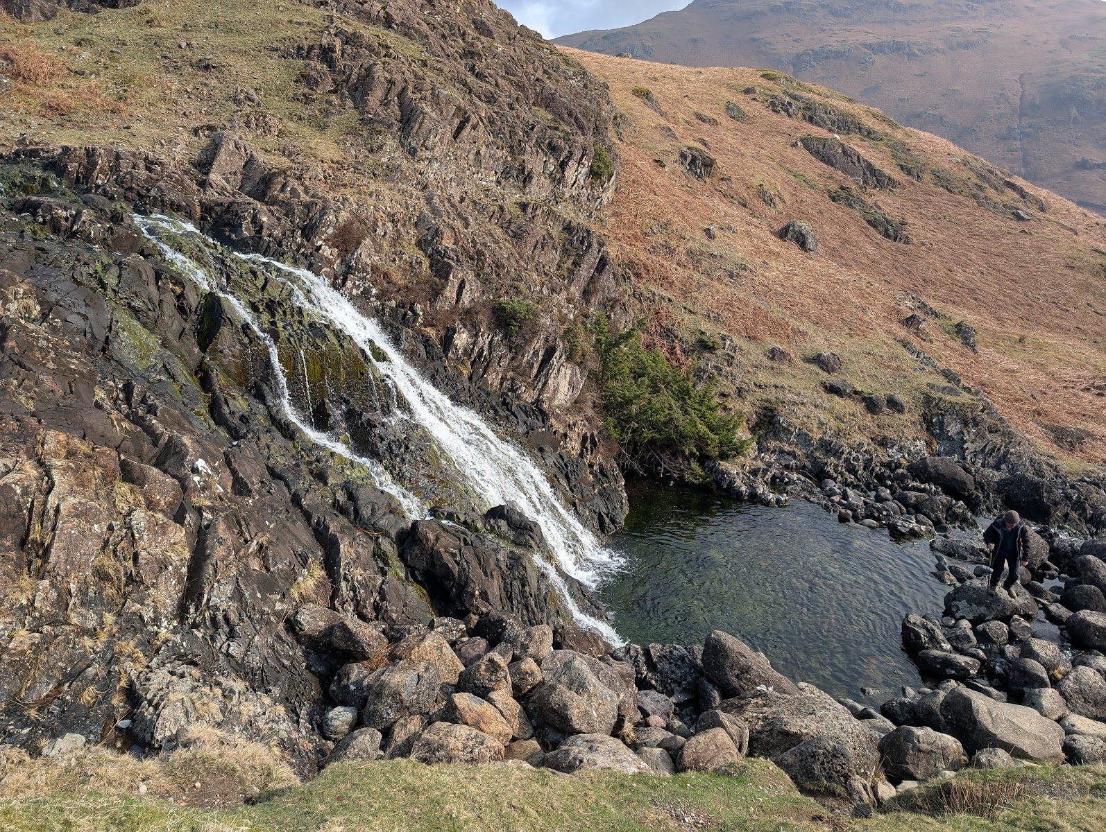
Sour Milk Gill is the white ribbon of cascades you can see from Grasmere village itself — the outflow of Easedale Tarn tumbling down the lip of its hanging valley in a long chain of falls and slides. After rain the whole gill churns white (that's the "sour milk"), and the sight of it pouring off the fellside is the traditional invitation to the Easedale Tarn walk.
**One thing to get right before you navigate anywhere: Lakeland has three Sour Milk Gills. This page is the Easedale one, above Grasmere**. The second falls from Gillercomb toward Seathwaite in Borrowdale (you pass under it heading for Taylor Gill Force country); the third drains Bleaberry Comb toward Buttermere below Red Pike. Same milk, different valleys — check which one your guidebook means.
Quick facts
| What it is | A long chain of cascades where Easedale Tarn's outflow drops toward Grasmere — no single big plunge, and all the better for it |
|---|---|
| The walk | The classic Easedale Tarn path from Grasmere — ~1.5 miles to the falls area, on a mostly good, popular path |
| Can you swim? | Not in the gill (shallow, rocky cascades); hardy swimmers head for the tarn above — open fell water, all the usual cold-water cautions |
| Dogs | On leads — sheep country the whole way |
| Pushchair / family | Path is good early on but rocky and stepped higher up — not pushchair ground; a fine family walk on foot |
| Getting there | On foot from Grasmere village (Easedale Road) |
| Best time | After rain, when the gill runs white end to end — the name only makes sense in spate |
| Above it | Tarn Crag and Blea Rigg around the tarn's basin |
Where is Sour Milk Gill (Easedale)?
Sour Milk Gill (Easedale) near Grasmere, in the Lake District. Zoom and pan to explore — or see every Lake District waterfall on one map.
The walk in
From Grasmere village, Easedale Road leads out past Goody Bridge to the footbridge at Easedale's mouth — and from there the paved-and-pitched path climbs steadily beside the gill, with the cascades for company most of the way to the tarn. The falls aren't one stop but a companion the whole middle third of the walk: slides, spouts and churning pools, best seen from the path (the rock beside the water is polished and slippery — admire from the pitching). Our Grasmere and Easedale Tarn route Walked June 2024 covers the full round: 9.5 km (about 6 miles) there and back, with a loop at the tarn.
Fells & walks near Sour Milk Gill (Easedale)
Straight-line distances from the centre of Sour Milk Gill (Easedale) — the nearest summits with a full guide on this site.
Places nearby: Easedale Tarn · Grasmere · Grasmere (the lake) · Great Langdale
All walks near Easedale Tarn → — the routes we have mapped and every Wainwright and Outlying fell within about 5 km of Easedale Tarn, ranked, with today’s conditions.
When to go
After rain, no contest — the gill in dry weather is a modest, pretty thing, but in spate it earns its name, a torrent of white the village can see from a mile away. It is a busy path, so early mornings and evenings are the quiet windows. The rock beside the water is polished and slippery, most of all when the gill is full.
The setting
Easedale is Grasmere's back garden — the gentle, walled valley the Wordsworths walked almost daily, with the tarn sitting in a perfect glacial bowl above it. The cascades mark the step in the hanging valley: farmland below, open fell above. At the tarn the scenery turns properly mountainous, ringed by Tarn Crag and the long rocky crest of Blea Rigg, with the path onward to Codale and the Langdale ridges for those going higher. A Victorian refreshment hut once stood at the tarn — its ruin is still there by the outflow, a reminder this has been a beloved easy day for 150 years.
The name & its story
All three Lakeland Sour Milk Gills earned the name the same way: water beaten white as churned milk as it falls. This one has the literary pedigree — the Wordsworths knew these falls well from their Dove Cottage years, and Easedale was by all accounts William's favourite short walk from home. "Gill," from Old Norse gil, is a ravine or beck-cut — and the tarn's name, Easedale, likely carries a Norse personal name too. The white gill above the green dale is one of the oldest picture-postcard views in the district.
Family, dogs & accessibility
A family fell walk with a real destination, cascades all the way, and a tarn at the top (open fell water — cold and unmanaged, with no lifeguard). The path is well-pitched but rocky and stepped in its upper half — no pushchairs; sturdy footwear for everyone. Keep small children on the path side of the gill: the waterside rock is polished-slick. Dogs on leads throughout — sheep the whole way. Facilities in Grasmere village only.
The fells above
Tarn Crag (Easedale) rises directly above the tarn and Blea Rigg walls its southern side — both make natural extensions for a bigger day, and Helm Crag guards the valley's other flank (our Helm Crag and Far Easedale round Walked January 2025 looks down on the whole gill). The rest of Lakeland's falls are in the Lake District waterfalls guide.
Getting there & parking
Without a car: The nearest stations as the crow flies are Windermere (14 km away) and Staveley (18 km away). The bus map has every stop we hold.
Walk from Grasmere village — there's no parking up Easedale Road (residents and turning only), and the village car parks (pay & display) are ten minutes from the footbridge. The 555 bus stops in Grasmere from Ambleside, Windermere and Keswick, making this an easy car-free waterfall walk. The falls are ~30–40 minutes' gentle walking from the bus stop.
Parking near Sour Milk Gill (Easedale)
All the car parks around Sour Milk Gill (Easedale) on the parking map →
Straight-line distances from the centre of Sour Milk Gill (Easedale). We publish whether a car park charges, and who runs it, but never the price — tariffs change and a stale one is worse than none, so check the sign or the operator’s own site on the day.
Vehicles are left entirely at their owner’s risk. We list places people park; we cannot vouch for any of them. Judge it on the day: take valuables with you, leave nothing on show, and if a spot feels wrong when you get there, park somewhere else.
Getting there across the Lake District: Buses · Parking map · By train · By boat
Events across the Lake District
Planning a trip around a show or festival? See our Lake District events & festivals guide for what's on near Sour Milk Gill (Easedale) — traditional Lakeland sports, agricultural shows and seasonal events, month by month.