hikes.guideLake District

Lake in the Lake District · getting there, parking and the fells nearby.

Lake

Brothers Water

Getting there, parking, where to stay and the fells you can walk straight from Brothers Water.

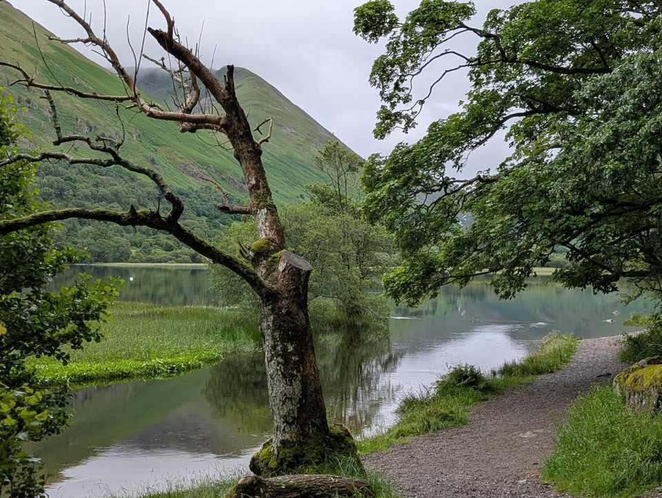
Brothers Water — a calm, reedy lake enclosed by steep green fellsides, with a bare leaning tree over the water beside the shore path
© Lee McCoy
On the tops

Fairfield today: Marginal · Summit likely clagged in

9°C at the summit, gusts 26 mph

Scored for 11 September by the site’s own scorer · all 214 today
First light

The sun reaches the Finishing of the Far Eastern Fells start about 07:58 in September · sunrise 06:45

From the terrain around the start (Copernicus GLO-30), mid-month · how we work it out
The last bus

From Hartsop, in road end: 17:44 towards Penrith Rail Station (508) and 15:50 towards Keswick Bus Station (K) (509) Monday to Friday; Saturday and Sunday differ

Signed off per direction against the operator’s timetable, 7 September · the bus map

Brothers Water at a glance

Brothers Water is one of the smallest of the lakes and one of the most quietly atmospheric — a still, reed-fringed water at the north foot of Kirkstone Pass, on the Patterdale/Hartsop side, cradled between steep green fells at the gateway to Dovedale. It's an easy 2.5–3 mile circuit, mostly level, with 16th-century Hartsop Hall on the far shore — and a poignant name whose story we tell honestly below. As lakes go it's small and unshowy, but it's a lovely, low-key spot and a perfect short walk.

Quick facts

What it isA small lake at the foot of Kirkstone Pass, near Patterdale / Hartsop
The walkAn easy ~2.5–3 mile circuit (Cow Bridge – Hartsop Hall – Low Wood), mostly level
Can you swim?Yes — done and popular; cold, usual care
The nameOnce "Broad Water"; renamed after two brothers are said to have drowned here
FeedsUllswater — it drains north via Goldrill Beck
Getting thereCow Bridge car park on the A592 (Kirkstone road) near Hartsop
Depth20 m at the deepest (confidence: low)
Length0.6 km (confidence: low)

Where is Brothers Water?

The district’s layer · every place page carries this

Brothers Water near Penrith, in the Lake District. Zoom and pan to explore — or see all the Lake District lakes & waters on one map.

The Hartsop circuit

The walk is the main event — an easy, mostly level loop of about 2.5 to 3 miles that's perfect for a half-day or an evening stroll. From the Cow Bridge car park, a level lakeside path runs down the western shore to Hartsop Hall, then returns through the woods and meadows of Low Wood on the eastern side. It's gentle, beautiful and quiet, with the steep fells of Dovedale closing in at the head of the valley. Our Fells & walks nearby box below has the surrounding summits, and the live conditions if you're heading up.

Why is it called Brothers Water?

This is the lake's most-searched question, and the honest answer is: it's a legend, not a settled fact. The water was once called "Broad Water," and the present name is generally said to come from two brothers who drowned here. The best-known version has two brothers drowning while skating, around 1812, when thin ice gave way over the lake's springs. But there's an earlier reference to "the Brothers" from 1789, and parish records have been linked to brothers named John and George Atkinson — so the dating doesn't all line up. We'd present it as exactly what it is: a poignant local etymology with more than one version, rather than a single verified event. Either way, the name has stuck for two centuries.

Hartsop Hall & the valley

On the western shore stands Hartsop Hall, a handsome 16th-century farmhouse (now a National Trust working farm) — one of the oldest buildings in the valley, and a lovely focal point on the circuit. Brothers Water sits at the very head of the Ullswater valley: its outflow, Goldrill Beck, runs north to feed Ullswater, and the lake is the gateway to Dovedale and the Fairfield/Dove Crag fells above.

Can you swim, and what fish are in it?

Swimming is done here — it's a quiet, cold swim with easy shore access — with the usual cold-water care (no lifeguards, ease in, it's cold year-round). The lake is small and shallow-ish, and like several Lakeland waters it holds perch, pike and trout among its fish; it's better known for its peace than its angling.

The fells

Brothers Water is ringed by fine fells and is a classic launch point for them: Hartsop Dodd and Brock Crags rise to the east above Hartsop village, High Hartsop Dodd and Dove Crag guard Dovedale to the south-west, and the Kirkstone road climbs over the pass behind. Check the Fells & walks nearby box below for the closest summits with full guides.

Fells & walks near Brothers Water

Straight-line distances from the centre of Brothers Water — the nearest summits with a full guide on this site.

All walks by Brothers Water → — every route and fell within about 5 km, ranked, with today’s conditions.

Parking near Brothers Water

Hartsop Dodd car park (free) — 0.3 km from Brothers Water (straight line)
Nearest fells: Hartsop Dodd (0.9 km), Gale Crag (1.2 km), Brock Crags (Wainwright) (1.6 km). Free (OSM-tagged). Compacted surface (OSM-tagged).
Directions (opens in new tab)
Free about 4 spaces
Checked 2026-08-10
Something changed here?
Cow Bridge, Hartsop (paid) — 0.7 km from Brothers Water (straight line)
Paid car park by Brothers Water — Hartsop above How, Dovedale, Caudale Moor. Fees: pay and display; coins and cards; RingGo ID 37323 (LDNPA, checked Aug 2026).
Directions (opens in new tab)
Pay & display
Checked 2026-08-02
Something changed here?
Gale Crag (layby) — 0.7 km from Brothers Water (straight line)
Walking base for Middle Dodd, Little Hart Crag (Little Hart Crag - West Top), High Hartsop Dodd and Gale Crag — the 'Middle Dodd Little Hart Crag and High Hartsop Dodd' route starts 56 m away. Also serves 'Hartsop Fells and Hart Crag'. Free (OSM-tagged). Unpaved surface (OSM-tagged).
Directions (opens in new tab)
Free about 10 spaces
Checked 2026-08-10
Something changed here?
Hartsop village (free, donation) — 0.8 km from Brothers Water (straight line)
For Hartsop Dodd, Gray Crag, High Street via Hayeswater, Brock Crags.
Directions (opens in new tab)
Free about 25 spaces
If it is full: Cow Bridge, Hartsop (paid) (0.9 km)
Checked 2026-08-02
Something changed here?
Hartsop Dodd (layby) — 1.1 km from Brothers Water (straight line)
Nearest fells: Hartsop Dodd (0.9 km), High Hartsop Dodd (1.2 km), Gale Crag (1.3 km). Free (OSM-tagged).
Directions (opens in new tab)
Free about 5 spaces
Checked 2026-08-10
Something changed here?
High Hartsop Dodd (layby) — 1.5 km from Brothers Water (straight line)
Nearest fells: High Hartsop Dodd (1.0 km), Hartsop Dodd (1.1 km), Gale Crag (1.5 km). Free (OSM-tagged).
Directions (opens in new tab)
Free
Checked 2026-08-10
Something changed here?

All the car parks around Brothers Water on the parking map →

Straight-line distances from the centre of Brothers Water. We publish whether a car park charges, and who runs it, but never the price — tariffs change and a stale one is worse than none, so check the sign or the operator’s own site on the day.

Vehicles are left entirely at their owner’s risk. We list places people park; we cannot vouch for any of them. Judge it on the day: take valuables with you, leave nothing on show, and if a spot feels wrong when you get there, park somewhere else.

How long from Brothers Water?

Walking routes starting near Brothers Water, with distance, ascent and our time estimate
RouteDistanceAscentEstimate
Angletarn Pikes and the Martindale round22.2 km1349 m6.7 hrs
Brock Crags, Angletarn Pikes, Beda Fell & Place Fell19.7 km1070 m5.7 hrs
Hartsop Fells and Hart Crag11.9 km765 m3.6 hrs
Hartsop Dodd, Stony Cove Pike, Thornthwaite Crag and Gray Crag10.0 km832 m3.4 hrs
Caudale Moor & St Raven's Edge13.0 km724 m3.8 hrs
Middle Dodd Little Hart Crag and High Hartsop Dodd10.4 km795 m3.4 hrs

Routes starting within about 2 km of Brothers Water, or on its doorstep at one of the car parks above. Estimates are moving time for a steady walker and take no account of stops, conditions or daylight — they are a guide, not a schedule.

Getting there & parking

Without a car: The nearest stations as the crow flies are Windermere (14 km away) and Staveley (16 km away); the 508 and the 509 stop at Hartsop, in road end, 0.6 km from here; the last bus back is 17:44 towards Penrith Rail Station and 15:50 towards Keswick Bus Station (K) Monday to Friday (Saturday and Sunday differ), signed off against the operator’s timetable on 7 September. The bus map has every stop we hold.

Brothers Water is on the A592 — the Kirkstone Pass road — between Patterdale and the top of the pass, near Hartsop village. Park at the Cow Bridge car park at the northern end (the usual start for the circuit), or in Hartsop village just off the road. It's an easy drive from Ullswater and Patterdale; from the south it's over the dramatic Kirkstone Pass from Ambleside. The car parks are small — come early on fine days.

Where to stay & practical

Base in Patterdale or Glenridding by Ullswater — inns, hotels, a YHA and campsites — a few minutes up the valley, with Ambleside over Kirkstone to the south. Brothers Water makes a perfect short, gentle walk to pair with a bigger Dovedale or Fairfield day, or simply an easy, atmospheric hour at the foot of the pass.

Frequently asked questions about Brothers Water

How long is the walk around Brothers Water?
The circuit is an easy 2.5 to 3 miles, mostly level, taking most walkers around 1 to 1.5 hours. From the Cow Bridge car park a lakeside path runs down the western shore to Hartsop Hall and back through Low Wood — a lovely short or evening walk.
Can you swim in Brothers Water?
Yes — it's a quiet, cold swim with easy shore access, and a popular spot. Take the usual cold-water care (no lifeguards, ease in, cold year-round). It's small and peaceful rather than a busy swimming lake.
Why is it called Brothers Water?
It's a legend, not a settled fact. The lake was once called "Broad Water," and the present name is generally said to come from two brothers who drowned here — the best-known version being two brothers skating around 1812 when thin ice gave way. But an earlier reference to "the Brothers" exists from 1789, so the story has more than one version. We tell it as a poignant local etymology rather than a single verified event.
Where is Brothers Water and how do you get there?
It's at the north foot of Kirkstone Pass, on the A592 between Patterdale and the top of the pass, near Hartsop village. Reach it easily from Ullswater/Patterdale, or over the dramatic Kirkstone Pass from Ambleside.
Where do you park for Brothers Water?
Park at the Cow Bridge car park at the northern end (the usual start for the circuit), or in Hartsop village just off the A592. Both are small, so come early on fine days.
How deep is Brothers Water and what fish are in it?
It's a small, fairly shallow lake at the head of the Ullswater valley (it drains north via Goldrill Beck into Ullswater). Like several Lakeland waters it holds perch, pike and trout, though it's far better known for its quiet beauty than for angling.

Events across the Lake District

The district’s layer · every place page carries this

Planning a trip around a show or festival? See our Lake District events & festivals guide for what's on near Brothers Water — traditional Lakeland sports, agricultural shows and seasonal events, month by month.