Scale Force
Getting there, parking, where to stay and the fells you can walk straight from Scale Force.
Summit forecast
Grasmoor summit, verdict for 27 October: Save it for another day · Too windy for the tops
10°C at the summit, gusts 67 mph
Weather on the tops, not whether a route suits you. One summit, the highest within 5 km, not the valley · scored for 27 October by the site’s own scorer · all 214 ranked · Weather data by Open-Meteo.com (opens in new tab)First light
The sun reaches the Buttermere village start about 08:50 in October · sunrise 07:42
From the terrain around the start (Copernicus GLO-30), mid-month · how we work it outScale Force at a glance
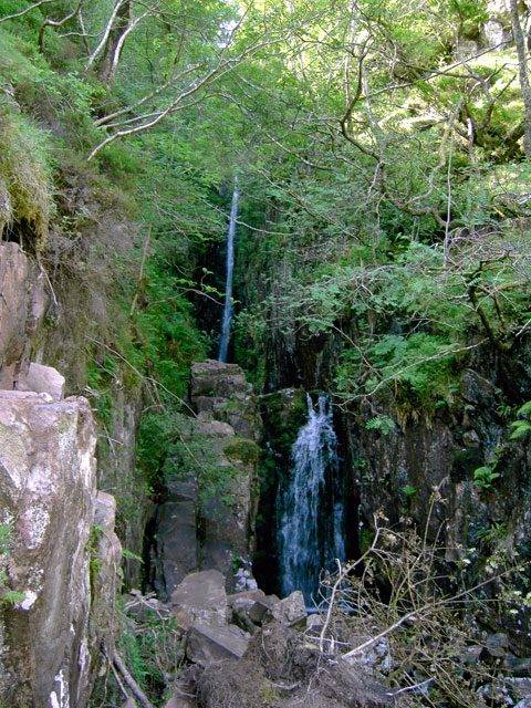
Scale Force is the Lake District's highest waterfall — a single ribbon of water that drops about 170 feet (52 m) through a deep, mossy cleft in the fellside above Buttermere. It's a very different creature to a honeypot like Aira Force: there's no car park at its foot and no tea room, just a rough, often boggy walk in from the valley to a hidden, fern-hung ravine. That remoteness is the whole appeal — it's the "highest and most hidden" of the famous Lakeland falls.
Quick facts
| What it is | Often called the Lake District's highest fall — a ~170 ft (52 m) drop in a mossy ravine |
|---|---|
| The walk | A rough ~4-mile there-and-back from Buttermere village, boggy in places (allow ~1½–2 hrs) |
| Can you swim? | A cold, dark plunge pool in a confined cleft, fast after rain; unmanaged, with no lifeguard |
| Dogs | Fine on the open fell (lead near stock); the ground is rough and wet underfoot |
| Pushchair / family | No — boggy, rough, remote; for fit walkers and sure-footed older children |
| Getting there | On foot only from Buttermere village car parks; no parking at the falls |
| Best time | After heavy rain, when the fall is in full spate; a dry, settled day for the boggy approach |
| The fell above | Red Pike (Buttermere) and the high western fells |
Where is Scale Force?
Scale Force near Buttermere, in the Lake District. Zoom and pan to explore — or see every Lake District waterfall on one map.
The walk to the falls
There's no shortcut to Scale Force — reaching it is half the experience. From Buttermere village the path crosses between the two lakes, over Buttermere Dubs, and heads out across open, often wet and boggy ground to the foot of the ravine, a round trip of about four miles with some genuinely soft going in places; allow 1½ to 2 hours with stops. The fall itself hides in a narrow, mossy cleft, so you come upon it suddenly — a tall white thread dropping into a dark, fern-hung chasm. Good boots are essential, and it's worth pairing with a low circuit of Buttermere, or a bigger day up onto the fells above.
Routes that start near Scale Force
| Route | Distance | Ascent | Estimate |
|---|---|---|---|
| Rannerdale Knotts from ButtermereStart 2.2 km away (straight line) | 4 km | 265 m | ~1–1¾ h |
| Scale Fell and MellbreakStart 2.2 km away (straight line) · not yet walked | 14.68 km | 572 m | ~3¾–5¼ h |
| The Buttermere RidgeStart 2.3 km away (straight line) · not yet walked | 13.39 km | 1012 m | ~4¼–6 h |
| Buttermere lake circuitStart 2.3 km away (straight line) · not yet walked | 7.41 km | 66 m | ~1½–2¼ h |
| Crummock Water shore circuitStart 2.3 km away (straight line) · not yet walked | 13.17 km | 191 m | ~2¾–4 h |
| Red Pike by Scale ForceStart 2.4 km away (straight line) · not yet walked | 9.25 km | 756 m | ~3–4¼ h |
More routes that start near Scale Force: High Stile, Seat via Buttermere (not yet walked) · High Snockrigg from Buttermere (not yet walked) · Great Borne & Starling Dodd (not yet walked) · High Snockrigg, Eel Crag & Lad Hows (not yet walked) · The Buttermere Ridge Anti-Clockwise
Routes starting within about 2 km of Scale Force, or on its doorstep at one of its car parks. Each time is the whole route’s, from a fast to a steady pace, and takes no account of stops, conditions or daylight — a guide, not a schedule.
Fells & walks near Scale Force
- Mellbreak (Mellbreak South Top)
- Starling Dodd
- Red Pike (Buttermere)
- Rannerdale Knotts
- Hen Comb
- Great Borne
Straight-line distances from the centre of Scale Force — the nearest summits with a full guide on this site.
Places nearby: Crummock Water · Buttermere · Moss Force · Loweswater
All walks near Scale Force → — the routes we have mapped and every Wainwright and Outlying fell within about 5 km, ranked, with today’s conditions.
Swimming
The pool at the foot of Scale Force is a deep, cold, shadowed plunge in a rocky cleft — the sort of place wild swimmers seek out, but one to treat with real respect. It's genuinely cold, dark and remote, with no help nearby and a long, boggy walk back out, and after rain the fall drives a lot of water into a confined space. There is no lifeguard and no managed access; the National Park's swimming safety advice is the place to start. For an easier swim, Buttermere and Crummock Water are close by.
When to go
Scale Force is all about water: after heavy rain or snowmelt it's a spectacular, roaring ribbon, and in a dry spell it can dwindle to little. The tension is the approach — the walk in is at its boggiest just when the fall is at its best — so the ideal is a clear, settled day soon after a wet spell. It's far quieter than the roadside falls year-round; a weekday gives you a real chance of having the ravine to yourself.
The setting & wildlife
The fall sits in a shaded, north-facing cleft where little sun reaches — which is why it's so thickly hung with mosses, ferns and liverworts, a lush micro-world in the rock. Around it is open, rough western fell: cropped grass, bog and crag, with ravens overhead and the big skyline of the High Stile range above Buttermere. It's one of the wilder waterfall settings in the Lakes, a world away from the manicured glens near the towns.
The name & its story
"Scale" comes from the Old Norse skáli, a shepherd's shieling or hut — the same root behind "Scales" and "Scale" place-names across the Lakes, marking where flocks were once summered. "Force", as ever, is the Norse fors, a waterfall. So the name simply records a waterfall by the old shieling — a plain Norse label for what became, in the age of the Picturesque tour, a much sought-out cascade.
Family, dogs & accessibility
This is not a family stroll or an accessible visit: it's a rough, boggy, remote walk with no facilities, so it's not suitable for pushchairs or wheelchairs, and it's best kept for fit walkers and sure-footed older children who are happy with wet ground and a longer day. Dogs are fine on the open fell — keep them on a lead around grazing stock — but remember the going is wet and there's no water source but the beck itself. Come properly booted and equipped.
The fells above
Scale Force spills off the flank of the high western fells beneath Red Pike (Buttermere) — the first of the great High Stile skyline above the lake. Strong walkers use the fall as the start of a much bigger day, climbing on to Red Pike and the ridge; most, though, simply make it the turning point of a wild valley walk from Buttermere.
Getting there & parking
Without a car: The nearest stations as the crow flies are Corkickle (17 km away) and Parton (17 km away). The bus map has every stop we hold.
There is no parking at Scale Force — it's walk-in only.
Parking, toilets and buses: Parking near Scale Force
Follow the path between Buttermere and Crummock Water, over Buttermere Dubs, and on towards the falls. It's a car-free-friendly valley too: the seasonal Buttermere bus links it to Keswick over the passes, so you can arrive without a car and make a full day of the walk in.
Parking near Scale Force
Toilets, food and shops near these car parks
Toilets: Buttermere village (opens in new tab) (about 285 m from Buttermere village (NT, paid), straight line, accessible)
Cafes: Syke Farm Tea Room (opens in new tab), Croft House Farm Café (opens in new tab)
All the car parks around Scale Force on the parking map →
Straight-line distances from the centre of Scale Force. We publish whether a car park charges, and who runs it, but never the price — tariffs change and a stale one is worse than none, so check the sign or the operator’s own site on the day.
Vehicles are left entirely at their owner’s risk. We list places people park; we cannot vouch for any of them. Judge it on the day: take valuables with you, leave nothing on show, and if a spot feels wrong when you get there, park somewhere else.
Can you stay overnight?
- Buttermere village (NT, paid) — run by National Trust, which does not permit overnight parking. “We don't allow overnight parking due to the impact on nature and wildlife, staff resource and visitors.” (checked 2026-08-05)
- Buttermere village (LDNPA, paid) — run by Lake District National Park Authority, which does not permit overnight parking. “The only legal places to park are on formal camp sites.” (checked 2026-08-05)
These are the land managers’ and the council’s own published rules, quoted. Where a car park is not listed here we have found no published rule for it, which is not the same as permission.
Getting there across the Lake District: Buses · Parking map · By train · By boat
Frequently asked questions about Scale Force
How do you get to Scale Force from Buttermere?
On foot only. From Buttermere village the path crosses between the two lakes, over Buttermere Dubs, and out across open, often boggy ground to the foot of the ravine — a there-and-back of about four miles, allowing 1½ to 2 hours with stops. There's no road and no car park at the falls, and good boots are essential for the wet approach.
How high is Scale Force?
Scale Force drops about 170 feet (52 m) in a single fall, which makes it often described as the Lake District's highest waterfall. It's a tall, narrow ribbon in a deep mossy cleft rather than a wide, powerful sheet — most spectacular after heavy rain or snowmelt, and much reduced in a dry spell.
Can you drive to Scale Force?
No — there's no parking at Scale Force and no road to it. You park in Buttermere village (the National Trust car park, which fills early) and walk in on the path between the two lakes, over Buttermere Dubs. It's a genuinely remote fall, which is much of its appeal.
Is Scale Force a hard walk?
It's moderate but rough rather than hard: no real climbing, but the ground is wet and boggy in places, remote, and with no facilities, so it needs proper boots, a map and a settled day. It's fine for fit walkers and sure-footed older children, but it is not suitable for pushchairs, wheelchairs, or a casual stroll in trainers.
Can you swim at Scale Force?
There's a deep, cold plunge pool in the cleft that wild swimmers seek out, but treat it with real caution: it's genuinely cold, dark and remote, with no help nearby and a long boggy walk out, and after rain a lot of water pours into a confined space. There is no lifeguard and no managed access; the National Park's swimming safety advice is the place to start. Buttermere and Crummock Water offer easier, safer swimming close by.
Events across the Lake District
Planning a trip around a show or festival? See our Lake District events & festivals guide for what's on near Scale Force — traditional Lakeland sports, agricultural shows and seasonal events, month by month.